
Large station footprints (covered earlier) pose a particular problem for surface transit modes with wide geometries: as with the expressway-interchange station I ridiculed then, the infrastructure grows to a scale so large that it dwarfs pedestrian circulation to/from the station.
Wide geometries particularly hurt the utility of water taxis, which rarely prove truly practical in modern cities. Boats have very wide geometries and require deep-water docks far from shore, usually half of the walk shed is wasted on water, and high-intensity land uses and high-capacity transportation connections are usually set far back from flood-prone shorelines. Thus, even North America’s busiest transit ferry (Vancouver’s SeaBus) is separated from the street by 300m (~1000′) of walkways:
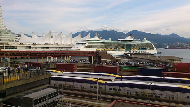
Thus, the ferry’s 400m/five-minute walk shed is limited to just one block beyond the station itself:

David Alpert recently suggested Vancouver-style ferries along the Anacostia, but the geometries of both the ferries and the waterways make this difficult. Even though I probably live closer to a water taxi dock than just about anyone else in D.C., I have yet to come up with an occasion to take the existing water taxi service — it’s super slow and doesn’t go anywhere useful.
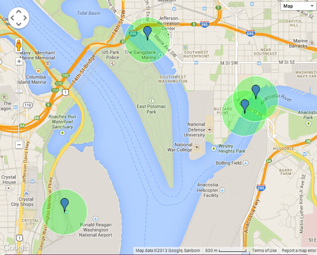
Because of Greenleaf Point (Ft. McNair) and Hains Point, the distances between the docks are much further via water than they are via land: the Wharf has an enticing waterfront, but it’s on the nautical equivalent of a cul-de-sac, 1.5+ miles away from the main stem of the Potomac. Thus, Wharf-Georgetown is twice the distance by water as by land, and thus it’s much faster to walk or bike between all of the water taxi stops. Even once riverfront sites like Buzzard Point, Poplar Point, and Reservation 13 get developed, the Anacostia Riverwalk Trail will be much more important as a mode of transit: it’s that much closer to land-side destinations, and available on-demand, 24 hours a day.
Ferries are slow compared to land travel: 30 MPH is “fast” in nautical terms, and 40 MPH is “high speed.” Thus, 1.5 miles means a 10-minute roundtrip time penalty just to get up to the dock, plus the not-inconsequential time spent actually docking. Ferries are surprisingly fuel-inefficient, since water displacement sucks up a lot of forward momentum.
What’s more, the landside transportation capacity isn’t really there most anywhere along local rivers. The walk shed from any ferry extends only 1-2 blocks inland (see the 400m walk sheds from Georgetown waterfront and Kennedy Center docks), and along most of the Potomac or Anacostia that space is taken up by highways, parkland (in the shallow tidal rivers), or steep hills (in the Potomac Gorge north of Roosevelt Island). Even in Alexandria, the quintessential port town, and at National Harbor, most of the activities and transport connections are set well back from shore. Just because a lot of things exist vaguely near the Potomac doesn’t matter, if the last-quarter-mile connections are awful. Already, we have lots of local examples of under-used transit that gets you sort of close to things, but not door-to-door.
Water taxis come closer to being time-competitive in situations like in Chicago, where land traffic congestion is appreciable and major activity centers like the railroad stations are within 200′ of the river — but where the river usually sits well below the (elevated) level of the streets around it. I’m hard-pressed to find many other examples in the USA where similar conditions exist, though.

Vancouver has two types of ferries – the Sea Bus across the Burrard Inlet (which you document here) and the False Creek micro-ferries.
Re: Anacosita, I think David was referencing the micro-ferries in his idea for the Anacostia. And if there were a private operator who wanted to do something along those lines, I think they should definitely be allowed to do so.
However, the micro-ferries aren’t a particularly efficient mode of transportation. They do connect to Granville Island, but they’re just as much about the experience – more so than about good transit.
The Sea Bus is something different – it’s high capacity, pretty fast, and a key link in the transit network. While it’s true that the Vancouver terminus involves a long walk over the railroad tracks, there’s something to be said for the ‘airport effect’ and walking distance. Even though you have to walk a bit, you don’t really have a choice of where to do and it’s not a harsh walking environment, thus that walking distance is somewhat baked in to the overall travel time. That’s not an approach that you want to use for most transit stations, but it can work for an exceptional case like this.
One of the other things I noticed while riding is that the ferries have pretty strong schedule adherence, allowing them to use countdown clocks on display throughout the terminal. If you’re so inclined, you can sprint across that bridge to catch the ferry.
I would also recommend checking out the North Vancouver terminus at Lonsdale Quay. There, the ferry dock is much closer to the shore; features a large bus transfer facility where bus service radiates out along the North Shore; and also includes substantial adjacent TOD.
If I were to think of a land-based analogue for good ferry service, it would probably be commuter rail rather than rapid transit.
The micro-ferries are cute and relatively cheap, but it’s a strange business model that depends on a whole lot of tourists, and on the unique situation of having very high bridges over False Creek. I could see a similar service evolving from NY Waterway’s cross-river services as high-density development marches closer to the Manhattan/Brooklyn/Jersey waterfronts (note how high intensity even the Hudson River Park is, due to its revenue-generation demands). However, it’s tough to see that working in many other situations: a 5-minute walk through a green riverfront park is still a 5-minute walk between transit and destination.
The to-the-second schedule adherence for SeaBus is indeed pretty amazing in the North American context. I can’t think of very many other transit systems that offer that sort of information.
Lonsdale Quay is built out over the water, which does a lot to mitigate the distance. The comparatively deep channel close to shore on that side, and the lack of pre-existing waterfront uses forming a barrier (e.g., the CP tracks leading into Vancouver Waterfront Station), make that possible — but both of those pre-conditions are relatively rare.
You’re absolutely right on the Lonsdale Quay conditions being relatively rare, even among cities with a strong port element.
One other thing that comes to mind in thinking about the micro-ferries on False Creek is that False Creek (at least when I was there) was a relatively calm body of water – both in terms of boat traffic and wind/waves. I wouldn’t want to be in one of those tiny boats out on the Hudson or the East River. Just one more unique element, I suppose.
I could see some entrepreneur taking on the micro-ferry idea in DC, even with a few changes (it’s not all that dissimilar from Baltimore’s inner harbor water taxi service), but this isn’t going to be some big time element of the transit network. It would indeed be the kind of service that relies on tourists to survive.
I would also note that in my anecdotal trip to Granville Island, we had to wait for a couple of boats to come by before one had enough room for our party. For the return trip downtown, we just took the bus.
The only possible use case I could foresee would be if Poplar Point, Buzzard Point, and the Florida Rock site all get built out at maximum density. Or if the East Potomac Park golf course gets developed; then we’re talking.
Baltimore is a particularly peculiar instance of a city that’s wrapped around water, rather than the other way around, but even there water transport is incidental.