
NCDOT recently reactivated plans to rebuild Raleigh’s busiest interchange, between I-40, I-440, and US 1/64 on the border of Raleigh and Cary. Much of the plan revolves around trying to fix the troublesome road arrangement that exists around Cary’s largest retail center, Crossroads Plaza. But how did this emerge?
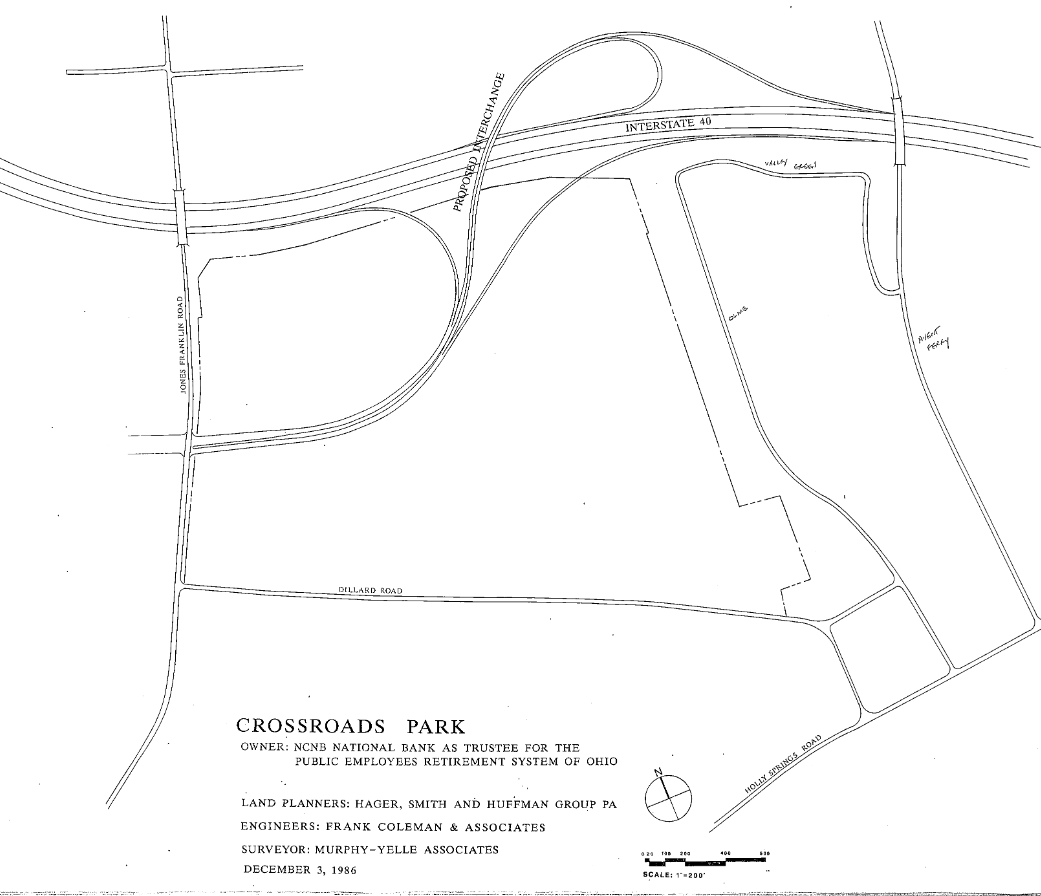
Crossroads Mall was originally proposed in the late 1980s, just a few years after I-40 was constructed around the west/south of Raleigh, by the Australian developer L.J. Hooker. Hooker proposed the Triangle’s largest enclosed shopping mall, just one of many they planned across America. (They only ever completed one, which did not do well.) The site had been assembled by NCNB (now Bank of America) and an Ohio pension fund, who also planned an office park to the south – hence, perhaps, the names Meeting Street and Columbus (as in Ohio) Ave.
Crossroads Mall was to have been surrounded by a bean-shaped ring road; the outline of its southern half exists today as Caitboo Ave. (Imagine if it arced around the north edge of the shopping center.) Four access roads would connect to the ring road: the largest would align with the existing 1/64-Walnut interchange, and three more access roads would connect the ring road to the west, south, and southwest. Offices, hotels, and more shops would fill in the land south to Dillard Rd.
Crucially, plans filed in 1986 showed Crossroads Blvd. extending east across Jones Franklin, then curving north and ending at its own dedicated Beltline/I-40 trumpet interchange, west of Avent Ferry Rd. This would have balanced access to the mall such that shoppers could approach it from freeways in four directions: US1/64 from the southwest (via Walnut), I-40 from the northwest and southeast (via Crossroads), and the I-440 Beltline from the northeast (via Jones Franklin to Crossroads).
Things went awry quickly. The Beltline interchange would require purchasing land from Raleigh’s Lake Johnson Park, and Raleigh hardly wanted to facilitate such a huge economic boon for Cary. The flyover ramp from US1/64 to Crossroads Blvd. was concocted as a hasty replacement way to get direct freeway access from Raleigh to the mall.
Hooker’s business empire — weighed down not only by boatloads of debt but also the fantastically stupid purchase of several fading luxury department store chains — rapidly collapsed in the early 1990s real estate bust, but not until after the Crossroads site was cleared and roads like Meeting St. and the 1/64 flyover were built.
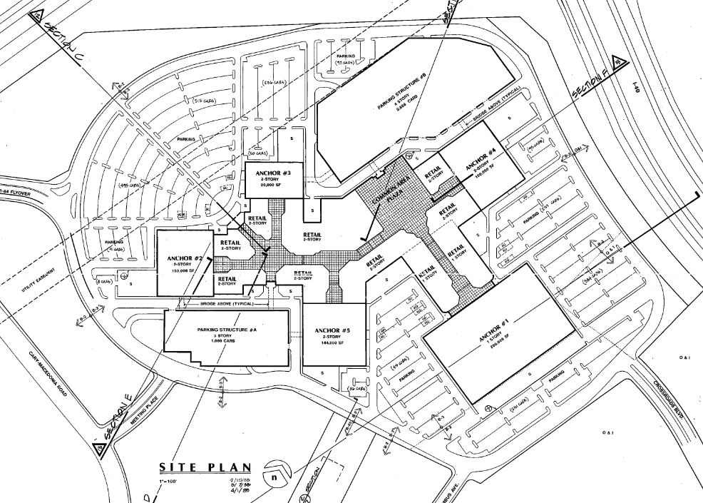
A new developer bought the site at a bargain price and, recognizing the shift underway from enclosed, full-price malls to “power center” strip malls filled with off-price discounters, redesigned the site for what was at the time the world’s largest power center. Instead of shops surrounded by parking and roads, the new layout required roads and parking in front of shops. But Caitboo and Crossroads had already been built south of the site, and a power line corridor meant that a good chunk of the site’s northern half was unbuildable. The solution was a ring of shops pierced by Crossroads Blvd, with Caitboo treated like a forgotten back alley. Even the vast power center didn’t fill the entire mall site; the cinema site was left undeveloped at first. (Note that what’s now Target and Home Depot was also owned by Hooker at the time.)
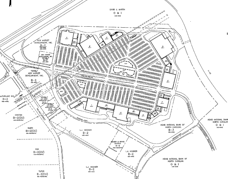
The reconfigured Crossroads Plaza was indeed a great financial success and spawned copycat developments all around it, adding to the strain on Walnut St. The road system there was cobbled together from various bits that were originally intended to serve a very different function. The original plan had access from the west and the east; instead, most mall access ended up coming from the west, which overloaded Walnut St. (Traffic volumes on Walnut are >3X higher than on Jones Franklin or Dillard, and ~30% higher right in front of Crossroads than on either side.) Once inside the mall, traffic was to have split up in both directions to flow right onto a ring road, which would distribute traffic around the mall. Instead, cars are mostly funneled onto one route: Meeting, then a left turn to Caitboo and right turn onto Crossroads.
What’s ultimately needed is to rebalance Crossroads traffic from the west to the south or east approaches, and that’s something that NCDOT’s plans make some progress towards by removing several Walnut St. exit ramps and aligning them with Dillard Dr. instead. Improved street network connectivity and improved wayfinding would also disperse vehicles away from just Walnut St.
(Originally posted to City-Data; images via Cary’s site plan archive)
