Air pollution used to be bad. How bad?

Circa 1907. "Pittsburgh by Night."

Seeing a photograph of streetlights on during the day in Pittsburgh prompted me to investigate how bad air pollution really was back then. Voila: a 1979 journal article by Cliff Davidson notes that typical Total Suspended Particulates (a now-deprecated measure) in Chicago in 1913 were 0.3-2.0 mg/m3, with a maximum of 9.3. Cleveland in 1915 reported an average of 14.3 mg/m3, and Pittsburgh was estimated at <7 mg/m3. All of those are many, many times higher than the current EU limit, which is 0.15 mg/m3 – about 99% lower than Cleveland a century ago.

BMA air quality exhibit

The Baltimore Museum of Art currently has an interesting exhibit of art from the turn of the last century, with a bit of added context: how gosh-darn smoke-filled the skies were back then. “Smog was visually stimulating and helped Monet see his urban environment in new ways.” It translates hazy scenes of London and Paris into air quality scores that would be nightmarish for present-day Americans, or challenging even for current residents of developing-world cities.

Tiny Japanese fire trucks, explained

Wee Japanese fire trucks, as some Stateside auto enthusiasts have discovered, are adorably, I-wanna-pinch-your-cheeks tiny. Here’s one on the streets of Onomichi:

Japanese fire trucks: streets of Onomichi

Of course, something this different doesn’t exist in isolation; there are systemic differences between Japanese and American fire response that allow and even require smaller trucks.

There are more, but smaller, trucks. Japan has smaller, specialized fire and rescue trucks, whereas America chooses to have larger, generalist trucks. Nagata Shozo, a disaster mitigation administration professor at Kansai University, says in a recent NHK documentary (see ~5m in): “In other countries, you may see a single vehicle that combines firefighting and rescue equipment… in Japan, we have a tradition of specialization… We improve the vehicles’ specific uses and capabilities, and when it comes to dealing with emergency, vehicles with different special features are used in combination to tackle the situation.”

At many fire stations I saw vehicles parked nose-to-tail, with garage doors on both sides of the building. A peek inside the Mukojima Fire Station in eastern Tokyo shows a second set of doors behind perhaps a dozen vehicles, including conventional trucks and van-sized ambulances. That is much larger than my brand-new local fire station (Engine , Truck , Ambulance ), which has just five bays.

Japanese fire trucks: Mukojima Fire Station

Equally capable equipment is smaller. A ladder truck inside the Shiba Fire Station is about the size of a typical US fire truck. This station is surrounded by new high-rises along the waterfront just south of the Imperial Palace.

Japanese fire trucks: Shiba Fire Station vehicles at night

Compare that to a ladder truck in DC, whose service area only has buildings up to 130′ tall (40m). [Or, check out this short video of a Japanese truck visiting a downtown DC fire station.]

US fire trucks: DCFD Truck 16, SE DC

A NACTO/Volpe report from 2018 calls out ladder trucks in particular as being peculiarly over-sized: “Aerial ladder fire trucks used in major European and Asian cities can reach just as high, despite being only two-thirds as long and having only half of the turn radius as common American models.”

By the way, the Shiba station was huge, with eight ranks of vehicles and garage doors in front and back.

Japanese fire trucks: Shiba Fire Station

There are even smaller vehicles. Note the rescue motorcycle at the right edge of the garage at the Arakawa Fire Department, Otonashigawa Branch. There were even cargo bicycles parked behind it. These can reach medical situations quickly even in pedestrian zones, or after earthquakes when roads may not be clear. (Mukojima above also had motorcycles.)

Japanese fire trucks: Arakawa Fire Department, Otonashigawa Branch

Fire stations are more numerous, and often mixed-use. Shinjuku-gyoen and Shiba are 3 miles apart, and there are five other fire stations in between them – meaning about one station every half-mile. Central Tokyo is dense, but not absurdly so; these areas have the population density of Brooklyn or the Bronx, not Manhattan.

A downside of having so many fire stations is that the land footprint is extensive, but that’s mitigated by combining fire stations into mixed-use buildings. None of the urban fire stations I saw were single-story structures.

Japanese fire trucks: Shinjuku-gyoen and Shiba are 3 miles apart, with five stations between

This isn’t just in urban areas; it also means putting fire trucks in remote areas, like this one stationed at the Enryaku-ji temple complex atop Mount Hiei east of Kyoto:

Japanese fire trucks: Mount Hiei (Enryaku-ji)

The small trucks respond to historically narrow streets – and enable narrow streets into the future. These tiny fire trucks can fight fires and respond to medical emergencies even though Japanese streets are famously narrow (often 4m, sometimes narrower), and just as importantly they allow new streets to be narrow as well. Contrast that with the absolute narrowest street I can build in Raleigh, which is 6.7m wide (34% wider) and requires a 40′ long fire truck turnaround.

Whatever they’re doing, it works. Japan’s fire death rate is substantially below America’s, which is notable given that its cities have historically been even more fire-prone than US cities. America’s “era of great urban fires” was over a century ago; by then, Tokyo alone had seen 49 large-scale urban fires in the preceding two centuries.

More importantly, given that the death rate for car crashes in the US (128 per million) is about ten times higher than the fire death rate (13 per million), the narrow streets and slower speeds found in Japan contribute to a traffic death rate that’s 3/4 lower per capita and 2/3 lower per vehicle.

Further reading:

High rises’ high cost, part 4: ecological cost, and the superiority of low-rise courtyard apartments

Earlier, I’ve written about how high-rise residential buildings have higher construction costs, land costs, floorplan efficiency, and maintenance costs than low-rise buildings. But leave it to some supertall skyscraper architects to make the ecological case for low-rise multifamily, with the book Residensity. The Chicago-based architects ran analyses on nine different arrangements for 2,000 residential units, from detached suburban houses to 215-story skyscrapers, and found that the optimal type was the humble courtyard apartment.

Park Castle panorama

This housing type, typical of medium-density lakefront neighborhoods in Chicago (see Moss Design), is a low-rise version of a European perimeter block. Multiple apartment entrances are arrayed around a courtyard, each reaching up to six flats (one on either side, for three floors). The deep courtyard evolved (see Ultra Local Geography) from the practice of putting apartment entrances along both streets on corner lots, and a clever response to Chicago’s relatively deep lots. They’re not quite single stair point-access blocks, though: each apartment technically also accesses a second stair — an exterior fire escape, usually built as a sociable rear porch. (21st-century building codes do not count this as a legal egress.) Courtyard apartments also allow for shallower, more usable interior floor plans; unlike mid-century “garden apartments” they structure open space into urbane settings.

The Smith/Gill team found that courtyard apartments had:

  • lowest embodied CO2 for buildings and infrastructure combined
  • lowest operating energy demand
  • 94% land savings vs. suburban houses
  • density that enables energy-efficient transportation modes

In some sense, this shouldn’t be surprising: the high construction costs and operating costs for high-rises are, in large part, paying for large quantities of carbon-intensive materials and energy to go into their construction and operation. The high operating energy demand reflects the large building surface areas that tall buildings have, as well as inefficient floor plans with extensive interior spaces. In a skyscraper, everyone on floor 150 has to travel indoors past everyone on floors 1-149 to get to anything outside the building; in a courtyard apartment building, most of that travel is outdoors.

Most striking to me is the density effect: high-rises aren’t incredibly more land efficient (shown by the green bars) than low-rise multifamily. For the same population, three-story apartments use 87.1% less land than suburban houses, courtyard apartments use 94.2% less, and high-rises uses 97-99% less land. Thus, low-rise apartments offer 90-97% of the land savings that high-rises do.

This paper also didn’t consider CO2 emissions from transportation: almost 1/3 of all US CO2. (The US accounts for 45% of the whole world’s transport CO2!) The greatest potential for transport CO2 reductions is to raise low densities to moderate, not high to higher: “the relationship between density and emissions is nonlinear,” says Grist about a PNAS journal article by Conor Gately — echoing Newman & Kenworthy’s finding from 1999.

Reading notes: housing price insurance, VMT & proximity

What I’m reading lately:

1. Lee Anne Ferrell, “Residents Against Housing” suggests an “insurance plan” that pays vulnerable tenants in gentrifying areas if their rent rises, despite welcoming new construction. This seems plausible in some limited scenarios, but I could imagine one where a neighborhood plan that envisions substantial residential growth is being implemented by a local taxing authority (e.g., a TIF, or a suburban town), and where payouts are indexed to regional rent inflation.

This is reminiscent of an insurance-based solution for the opposite urban succession situation: home equity insurance, intended to assuage homeowners worried about house value decline caused by neighborhood demographic shifts.

2. Adie Tomer and Caroline George for Brookings Institute, “Building for Proximity“. The amount that Americans travel is truly bonkers: miles traveled per capita per day doubled from 19.5 1969 to 40 in 2017, distances that are impossible to achieve without a car. “Americans simply travel too far, using cars too often. National trip distances easily exceed global economic peers.” Americans travel further for no good reason, besides the fact that we’ve been doing it this way for decades.

Even Americans living near activity centers travel a lot: almost 24,000 miles (the distance around the globe) per household per year. But those living far (10+ miles) from metro activities travel an extra 17,000 miles, or 2/3 of the way around the globe!

“While individuals have little control over manufacturing processes or electricity generation, where one chooses to live and travel is their most significant environmental decision.” The same goes for communities, and yet trip distances reduction figures into few local government climate action plans.

The graphs in the report show a somewhat logarithmic relationship between proximity and VMT. Too many transit-oriented development plans have hewed too closely to overly narrow radiuses (e.g., 1/4 mile to transit) which don’t have substantial basis in scientific literature. TOD effects are strongest closest to transit, but that doesn’t mean that areas 0.26 miles from transit are automatically “too far” and should be reserved for very low density detached houses. Yet that’s how generations of planners zoned “TOD,” with sharp density distinctions.

GTA: in the foreground is Mississauga. Its skyline bests Phoenix for the number of skyscrapers - yet there's no rail transit, and you've never heard of it.

3. Lida Weinstock for Congressional Research Service, “U.S. Housing Supply: Recent Trends and Policy Considerations” (July 2023). “New housing units… have trended downwards in recent decades.”

“Relatively low housing supply, especially when demand for housing is strong, can cause undesirable frictions in the housing market. One of the main results of low supply has been decreasing affordability.”

“[E]ven if there are technically enough units to house the population, that may not be true at certain price points or in certain locations,” a point misunderstood by “vacancy truthers.”

4. Richard Kahlenberg, “A Way Forward on Housing“. Ritchie Torres: “Exclusionary zoning produces and perpetuates housing segregation by race and class, which in turn produces and perpetuates school segregation by race and class.”

Contrast that to Patricia McCloskey speaking to Donald Trump’s Republican National Convention, warning that ending “single family home zoning” would bring “crime, lawlessness, and low-quality apartments into now-thriving suburban neighborhoods.” [Or, I’d add, Ben Carson and Donald Trump’s co-signed WSJ editorial: “a relentless push for more high-density housing in single-family residential neighborhoods, has become the mainstream goal of the left.”

“Large developers… may actually benefit from a more complicated regulatory structure that prices out smaller operations.” This is attributed to “Boston University researchers,” but fits into the Bruce Yandle-inspired “bootlegger and Baptist coalition” model of how big developers and NIMBYs both benefit from restricted growth.

All low-cost housing is subsidized

Housing variety
Townhomes on Capitol Hill, aka Ellen Wilson Place: directly subsidized and cross-subsidized housing

The high cost of new houses doesn’t exist due to greed alone. The cost of constructing and maintaining housing is too high for many to afford. Whether we recognize it or not, all low-cost housing has been either explicitly or implicitly subsidized by somebody else:

– A new inclusionary-zoned apartment is being subsidized by its neighbors.

– A new Habitat house was subsidized by volunteers, donors, and probably the local government.

– A new LIHTC apartment was subsidized by the federal government and maybe local/state government; its construction costs may even have been higher than the “luxury apartments” nearby.

– An old, cheap house in a declining milltown was subsidized by prior owners who sold it at a loss, and will only remain cheap by deferring maintenance, which means future occupants will pay more.

– A cheap house in a distant suburb is directly subsidized by $1T in annual subsidies for US sprawl; these subsidies have declined since their postwar introduction, but they spun up giant industries which can mass-produce sprawl cheaply. Meanwhile, tremendous indirect subsidies make driving, and thereby car-dependent sprawl, unrealistically cheap, with huge costs for human and planetary health.

Simply demanding lower-cost housing will not lower the cost of housing, any more than demanding lower-cost groceries will. Somebody has to actually write down that cost. (Notice that we don’t have fights over whether to provide subsidized food, because we provide it everywhere — through agricultural subsidies and food stamps.)

Local government CAN do something about the cost of housing, of course. It can reduce all the major costs of housing inputs — land costs, construction costs, and “soft costs”. Upzoning directly reduces per-unit land costs. If upzoning allows smaller, simpler, and more standardized housing units, those can reduce construction costs per unit. If upzoning makes permitting simpler, it can reduce “soft” costs. Best of all, upzoning is entirely within local governments’ control and costs nothing out of pocket. But all of these will only reduce the cost of providing housing somewhat; I can’t promise any silver bullets.

Governments also can direct, or redirect, subsidies that directly or indirectly lower consumer housing costs. This is especially important “for low-income families, [as] the only way to bridge the gap between incomes and housing costs is through public subsidies” (Brookings): for the 26,000 households in Raleigh who earn less than $20K, an “affordable” rent is <$500, which is less than it costs to *operate*, much less build, a minimum-quality apartment.

But most of those subsidies are beyond local governments’ authority or fiscal capacity; covering rent for just those 26,000 households would cost $156M a year, equal to hiking city property taxes by 50%! So local governments have to do what they can, while also working with other governments and the private sector to get more resources AND reduce costs.

(It’s worth noting that in the 1971 law review article where Paul and Linda Davidoff coined the very term “inclusionary zoning”, they noted that it was a tool to be used WITH additional government subsidy: “changes in local land use controls combined with the infusion of new funds and new forms of aid from the federal government to permit the construction of vast amounts of moderate-income housing” [emphasis added]. “Inclusionary zoning” was never meant to shift the burden of funding affordable housing onto developers, but rather to have developers participate in the construction of government-funded affordable housing. The original Montgomery County Moderately Priced Dwelling Unit program only provided low-income housing because the county purchased moderately priced units and subsidized their rental to low-income households.)

And yes, a formula of more housing + more subsidies works. It works in many other countries; all the exemplars of social housing build many more units than the US per capita, and spend much more in public subsidies. It even worked in the US during the Great Society era; in 1970, 46% of multifamily housing starts were HUD subsidized! Then Nixon, fearing backlash from white suburban homeowners, eviscerated HUD’s budget, and federal subsidies never really returned.

The lowest-hanging fruit, and one that (as others have written) Wake County in particular has been attuned to, is preserving existing lower-rent apartments. Allowing new multifamily houses to be built in R zones will relieve the pressure to redevelop the RX-zoned land underneath existing apartments. Wake County’s new subsidy dollars can be matched with untapped federal dollars (namely, NCHFA bonds + 4% LIHTC). Clever developers can densify around existing buildings, especially with relaxed parking requirements.

That’s now happening right now (instead, existing apartments are flipped or torn down for pricier units) because of exclusionary zoning’s evil twin, “expulsive zoning.” Zoning’s original intent was to comfort the comfortable (by surrounding rich and white people’s spacious houses with more spacious houses, aka “exclusionary zoning”) while afflicting the afflicted (by packing apartments, commercial, and industry next to one another, aka “expulsive zoning”). Andrew Whittemore at UNC has researched the history of Durham’s zoning and found ample evidence of expulsive zoning at work for generations. While he’s found matters have improved slightly since 1985, today’s zoning map is almost identical to 1985’s. The twin demons of exclusionary and expulsive zoning still haunt the zoning map today.

YIMBYism isn’t about doubling down on the exclusive/expulsive dichotomy. It isn’t “more of the same,” and doesn’t seek to perpetuate the inequality that’s baked into current development patterns – which directly lead to rising costs, displacement, and further inequality.

YIMBYism is about abolishing that dichotomy.

Adapted from an email sent to a Raleigh listserv 

Back to the future with California Forever

The future is electric!

A common complaint about the grandiose California Forever “new town” project in Solano County is that the site is just too far out there. The few 1970s New Towns that succeeded through to the present day were only 10-20 miles from growing job centers; the Solano site is a good 50+ miles from any major job centers (Berkeley or San Francisco) and 70+ miles from Silicon Valley itself. Distance wouldn’t be such a problem if only transport connections were better.

Ironically, though, the California Forever site is bisected by the remains of the Sacramento Northern Railway, an electric interurban railroad that once shuttled passengers between the Bay Area, Sacramento, and even far beyond Sacramento to Chico. Not only does much of the rail corridor still exist through there, but 21 miles of track is owned and preserved by the Western Railway Museum, which even maintains 5.5 miles (south of route 12) with live 1200V catenary — on which it runs former East Bay interurban equipment.

It’s puzzling that WRM’s track doesn’t seem to figure into California Forever’s plans at all so far, even as some kind of “future connection.” That may be because it’s of little practical use: even though the Sacramento Northern in theory once reached Pittsburg (now a terminal station for BART), it did so via a time-consuming car ferry across the busy, windy Suisun Bay. A new bridge would be prohibitively expensive; a ferry would be both difficult and silly, as both ends now sit in wetlands and some kind of shuttle would still be needed on the Pittsburg end (which is miles short of BART).

(This post began as a LinkedIn comment for Benjamin Schneider’s blog.)

Water woes won’t save Midwestern cities, and won’t sink Western cities

Route 5

Lake Erie waterfront in winter, viewed from Buffalo City Hall (all photos mine)

When I lived in Chicago, a common line of reasoning among locals (including me) was that Great Lakes cities were destined to triumph in the 21st century for the same reason they did in the 19th — its access to bountiful fresh water. Joel Brammeier, a Great Lakes advocate, notes that “Great Lakes residents like to believe that our water will save us” in CityLab, but also refutes the claim.

Upon further examination, this neat tale seems to be another popular notion that intuitively feels right, but falls apart upon further examination. I’m not post-hoc justifying Southwestern urbanization; I live in the east, because I enjoy looking at trees and rivers. But I’m not kidding myself that humans need those things.

1. The big reason why eastern US cities historically were built around water isn’t because humans drink hundreds of gallons per day, or even because 19th-century industry needed unlimited water; it’s because pre-railroad shipping used to be entirely water-borne, and pre-steam industry was entirely water-powered. Neither has been the case for over two centuries now.

Spillway

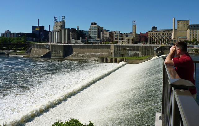
The Mississippi’s falls at Minneapolis, useful first and foremost for milling, secondly for shipping, and (a distant third) for drinking – 3/4 of its region’s water is from wells 

The amount of water used in industry has also declined substantially; treatment is a requirement now whereas before the approach was just to rinse everything down the drain. Wastewater recycling is how semiconductor fabrication, one of the most water-intensive manufacturing uses, thrives in Phoenix. Even water-intensive factories employ many fewer people than they once did, and water-borne shipping is mostly important for low-value bulk commodities (e.g., grain) which don’t create large numbers of jobs.

House

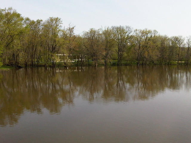
The Fox River at Plano, Illinois

2. Even a city the size of Chicago doesn’t “need” Lake Michigan quantities of fresh water, because again, actual in-home water use isn’t that high. Chicago (which also supplies most of its suburbs with water) draws one billion gallons a day from the lake — but that’s about as much water as the comparatively small Fox River, in the western suburbs, delivers (annual average). You don’t need a 3,000 year supply of something that you can simply reuse.

Chicago needed vast quantities of water in the 19th century, when dirty water was simply dumped untreated into waterways. But now treatment technology has advanced to the point where reclaimed water can be sent right back into drinking water filtration plants. It’s even used by Midwestern agricultural and industrial users, as a Wisconsin professor points out. Chicago finally began “tertiary treatment” (disinfection) of wastewater in 2015, and now local municipalities are investigating its use.

Most planning around water resources has shifted from thinking about drinking water, wastewater, and stormwater as separate categories to instead thinking about all three as “One Water.”

3. There’s ample water for urban use in the Southwest. Most water in the Southwest currently goes to agriculture, which seems absurd at first glance but makes sense considering the economics of the early 20th century: all that sun is good for plants, even if water needs to be imported at a then-reasonable cost. Replacing that agriculture elsewhere will require different inputs, like energy.

California Coast Starlight

California vegetable fields

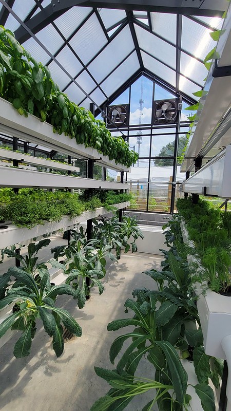
The good news is that food production can and will shift as the cost of agricultural inputs shift. As the cost of water is rising, and the cost of electricity is declining, vertical farms can now provide competitively priced leafy greens (a big Arizona/California export). Lighting was expensive in the early 20th century, but it’s getting much cheaper thanks to LEDs and cheap renewable power; vertical farms use drastically less water and fertilizer, can be mechanized more easily, and are closer to consumers.

Vertical farming

4. Urban water prices would have to be unrealistically higher to dissuade population growth. For a family that doesn’t irrigate outdoors, the spread in monthly water bills from the Rust Belt to the Sun Belt is absolutely negligible. In 2010, a monthly water bill for a family in Las Vegas cost $1 more than in Chicago. San Diego had much pricier water ($16 more each month), but that was just 0.5% of a median family’s budget. (That’s peanuts compared to homeowners’ insurance in Florida, which costs several thousand dollars more per year yet hasn’t done much to dissuade newcomers.)

San Diego already gets much of its water from high-cost desalination, so its water rates are pretty much as high as municipal rates will get. At such prices, it makes a lot of sense to do desalination, water recycling (Las Vegas recycles 99% of indoor water use), extreme water conservation measures (like those that have cut metro Las Vegas’ water use substantially despite population growth), diverting water from irrigation and agriculture (80% of Colorado River water!), or shipping water from far away.

5. With water recycling, even Los Angeles technically doesn’t need to import water: ‘ “It will take a lot of work, but 100 percent local water is possible by 2050,” said Mark Gold, UCLA’s associate vice chancellor of environment and sustainability.’ It’s technically feasible for LA to support its population on rainwater, groundwater, and recycled water alone — not even desalination!

6. Meanwhile, it’s not as if Great Lakes states don’t also have costly drinking-water infrastructure needs, from combined sewerage to lead pipes to agricultural pollution — all of which will require costly infrastructure investments to catch up to Western cities’ water-recycling tech. As Brammeier writes, “The infrastructure, governance and incentives for economic development we swore by during the 20th century are no match for the impacts of climate change.”

Olden days' infrastructure

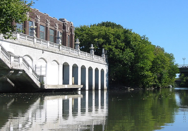
Midwestern urban water infrastructure, like this elegant but smelly sewage pump along the Chicago River, can’t be taken for granted.  

The Midwest also faces its own own climate change hazards; these aren’t as dramatic as sea level rise or megadroughts, but shouldn’t excuse the status quo. Fierce rainstorms and floods threaten flat, paved-over cities; Houston-esque heat and humidity will make summer unbearable in much of the Corn Belt and especially the Mississippi and Ohio valleys; and “polar vortex” cold snaps will get more frequent and severe during the winter as cold air spills down from the rapidly warming Arctic.

Support for Z-18-22

Dear Raleigh City Councilmembers,
I urge you to support Z-18-22, the Western Boulevard TOD overlay mapping. I grew up along this corridor; my parents have lived along this corridor for nearly 50 years, as my father had a long career teaching at NCSU. The sharp contrast between the lively, pedestrian- and transit-oriented Hillsborough Street corridor north of NCSU and the dangerous, car-oriented Western Boulevard corridor south of NCSU was something that even as a small child I recognized as an urban design challenge. Now I’m an urban planning professional with 20 years of experience in the field, and I’m thrilled to see that the city finally has passed CP-10-21 and is considering Z-18-22 – a realistic, actionable implementation plan that will guide the transformation of Western Boulevard into something better than a traffic sewer.

My family’s familiarity with these neighborhoods is why we are invested in property there – and why we’re now working with the City of Raleigh’s real estate department to sell land that we own within this area for subsidized affordable housing development. We are selling at a discount to what we could get on the open market because we strongly believe in the vision set forth by the city’s adopted Western Boulevard Corridor Study (CP-10-21). I have seen many attempts over decades to realize the potential of the ​complicated intersection of Western, Hillsborough, Jones Franklin, Buck Jones, and Chapel Hill roads, but none have come to fruition because they were not matched by ​sufficient ​public infrastructure investment. This Bus Rapid Transit Line, ​which was funded​ through a referendum of Wake voters in 2016, provides that impetus​ -​ and has been matched by ​city voters’ 2020 funding commitment to​​ affordable housing.

At tonight’s public hearing, you will hear a great deal of misinformation, fear, uncertainty, and doubt about the changes portended by this proposal. I’ve listened closely to previous public comments against this proposal, and one thing that’s struck me is that almost all of the complaints identified are about results of the *PRIOR*, car-centered development ​paradigm that​ resulted in the Western Boulevard we have today – and which, as long as the existing zoning remains, is still the legally mandated status quo that must be maintained.

Much of this corridor retains zoning that was enacted in 1960. The “against” side ​seems to ​think that, by keeping the legal fiction of 1960 zoning on the books, they can bring back the world of 1960 and its​ world of​ modest houses on large lots along spacious roads. That’s a view of the world that belongs in an antique store; zoning is a law, not a time machine. The problems of today resulted from past decisions like low-density zoning, and particularly the mismatch between 62-year-old laws and present-day realities​:​ a much larger population, much greater household diversity, and better knowledge of environmental consequences. Preventing changes ​that update those old laws​ will​ only exacerbate that mismatch​​.

1960’s zoning may have made sense here at a time when NCSU had 6,500 students (the size of Elon College today), RTP was an empty promise​ with zero jobs​, and when Wake County had fewer than 170,000 residents (the size of Pitt ​Count​y​ today). ​That zoning may have made sense then, before we knew that car dependence kills millions annually from crashes and from air pollution, or threatens the lives of billions through the global warming it causes. It may have made sense ​then, ​when federal officials, in thrall to the auto and sprawl industries, were handing out money for highways and ticky-tacky subdivisions​. It may have made sense then, when local officials sought to use zoning to separate (and restrict) races and classes and family types.

​​Our world is different today, I hope our public officials know better today, and our zoning laws should reflect​ today. 1960’s low-density zoning makes no sense in the world of 2022, where NCSU has 34,000 students, we know there are better transportation choices than driving, and where low-density zoning results not in modest old houses​ -​ but rather $900,000 McMansions​ here,​ and commuters​ to here forced to​ driv​e​ in from 5​0 miles away.​

Z-18-22 is a bold and different approach that will address (but cannot​, like any one policy,​ solve) the complaints that the “against” side makes. Instead of 16 luxury townhouses, my family’s land can become 100 affordable apartments and a park. Unlike those who blame (as yet untried!) Z-18-22 for higher housing prices, we know that this rezoning will actually do something about the lack of more affordable housing choices. Only 1% of all American houses are new in any given year, so laws should allow that 1% to best reflect the houses we want in the future​.​ Z-18-22 clearly states that ​Raleigh want​s​ more choices, not just $900,000 mansions.

Allowing more homes to be built, especially smaller houses (using less materials) that use less land, absolutely will ease the housing affordability crunch. As Congresswoman Alexandria Ocasio-Cortez says, “the reason why people are on the streets isn’t just some elusive housing or market phenomenon. It’s because we’ve chosen not to build.” The voters of the city of Raleigh have risen to the challenge by approving funding for affordable housing, but now we need places to put it – and Z-18-22 does just that. Raleigh does not want to be in the situation where Oakland was in 2018, where mayor​ Libby Schaaf​ said “we had local bond money to purchase new shelters, but could only find one building. We ​[didn’t] have enough building stock to create supportive housing.”​ Nor does Raleigh have to be; through its zoning powers, it can create many new opportunities to create new housing at many price points.​
The Western Boulevard corridor will continue to transform with the times; that much is certain. What we are choosing is whether to continue the deadly, unsustainable, unaffordable, unfair status quo chosen in 1960 – or to pursue the transformation that Wake County voters affirmed in 2016 by voting to create BRT on Western Boulevard. Z-18-22 is another step towards fulfilling the voters’ shared vision of Wake County voters – and another step towards ensuring continued funding from the Federal Transit Administration, which is closely evaluating whether federal taxpayers’ monies are well-spent in places whose zoning laws truly welcome transit.

I thank you for your attention. I look forward to further working with the City of Raleigh to advance our shared vision of a greater Raleigh.​

NCAP testimony for NHTSA

A safety crisis is unfolding on America’s streets. Pedestrian and bicyclist deaths have increased by 50% over the past decade, and overall motor vehicle deaths last year increased by the largest percentage in US history. This is a phenomenon unique to the United States; since 2010, US road deaths increased by 31%, while EU road deaths DECREASED by 33%.

Clearly, what NHTSA has been doing has not been enough. Many of these deaths could have been avoided with better car safety standards and in particular an improved New Car Assessment Program (NCAP). Every other NCAP program elsewhere in the world has long evaluated safety for road users outside of the vehicle. Indeed, the UN’s 2011 Global Plan for the Decade of Action for Road Safety specifically highlighted “application of pedestrian protection regulations” within vehicle safety regulations (Pillar 3, Activity 6).

I commend NHTSA for finally taking the first steps to stem this wave of preventable deaths and injuries. What’s proposed is not nearly enough, and does not meet standards accepted elsewhere in the world that protect people on foot, on bikes, and using mobility devices from the increasing threat of large vehicles.

I join America Walks, the National Association of City Transportation Officials, and other organizations to ask that NHTSA protect people outside of cars with an NCAP that measures and rates:

  1. Smaller and safer hood and bumper designs to reduce fatalities and serious injuries for people outside vehicles;
  2. Features capable of sensing and protecting people outside vehicles, including children, bicyclists, people using mobility devices, and people with darker skin tones;
  3. Intelligent speed assistance systems that automatically limit unsafe speeds;
  4. Direct visibility requirements that allow drivers to see people outside of vehicles, especially children. Cameras, mirrors and sensors cannot replace the need for direct sight.

Critically, vehicles that score poorly on pedestrian protection, direct visibility, or that allow dangerous speeding should be ineligible for 5-star ratings. Even the most advanced ADAS technologies have proven insufficient at preventing deaths.

NHTSA also must move to incorporate the same technologies and designs into the Federal Motor Vehicle Safety Standards (FMVSS).

Vehicle safety standards that save the lives of people outside cars shouldn’t be left to consumer choice. NHTSA mandates equipment like seatbelts and airbags that protect vehicle occupants; it needs to update the FMVSS to protect everyone on our streets, not just those in vehicles.

[Adapted from America Walks]

Idle speculation: US-1 edition

Some people watch “House Hunters” for hours on end, and others peruse Curbed to imagine themselves inside huge mansions. Personally, I’m partial to idly imagining what could happen with those quirky old buildings that show up on the commercial listings.

College Park US1
(Baltimore Avenue looking south from College Park towards Hyattsville and Riverdale Park)

4415 Oliver Street, a two story house turned office just off Route 1 in the Hyattsville Arts District could be renovated into a version of the Form Follows Finance Fourplex. (It might even qualify for a conforming residential renovation mortgage.) It has the right live-work zoning, which is surprisingly scarce in downtown Hyattsville. At $350K for 1800′, it’s cheaper than nearby houses–around the corner, the same $350K only buys you a 1200′ house. OK, so it might only fit 2-3 units instead, but still a good price for someone with some architectural ingenuity. Indeed, it even pencils as a teardown.

An interesting Opportunity Zone play nearby: a 33 acre strip mall at the doorstep of the future Riverdale Park-Kenilworth Purple Line station (one stop from UMd’s research park) is for sale, though probably for a high price. The new, but as-yet unmapped TOD zones in Prince George’s give very wide latitude to its future owner.

Elsewhere in Riverdale Park, there’s a <2 acre residential tract for sale. Looks at first glance like an interesting pocket neighborhood opportunity ( close to downtown Hyattsville! might be able to do something unusual with the street ROW!)–but even the brand-new zoning code only allows large-ish single-family houses there. Blah.

In other news, Forest Glen‘s Castle is back on the market at $2.8 million. I have zero ideas for it; after reading about the place, I’m utterly unable to picture it as anything other than “the Hungarian Whorehouse.”

After those cheers, some (more) jeers for Fairfax County. This vacant quarter-acre lot on Richmond Highway, which appears to be a leftover from a prior subdivision, looks at first glance like a prime chance for a residential scale live/work-plex. But no: “Highway Commercial” zoning doesn’t allow residential by the 7-11 and Five Guys, even though the local sector plan calls for three-story mixed-use. Instead, it would require apartment (or PUD!) zoning… which requires a 2.5 acre minimum lot area, because this is the suburbs. OK, so technically that MLA doesn’t apply in redevelopment areas like Richmond Highway, but c’mon Fairfax, it’s the 21st century, individual vertical mixed-use buildings exist.

Idle speculation: Opp Zone, meet planned community

The Opportunity Zone maps for greater Washington and for Raleigh had two particularly puzzling inclusions: the Lake Anne area in Reston, and the Kildaire Farm area in Cary. How is new investment intended to transform planned communities, which had always been intended to remain exactly the same?

I happen to have a soft spot for both areas (pioneering planned communities in their respective areas) so I looked around at both and just could not figure out how this is expected to work.

OZs require drastic change
In order to qualify as an OZ investment, a real estate investment has to meet the “substantial improvement test” — similar to the Historic Tax Credit. This essentially means that a renovation must “double the basis,” or spend as much on the improvements as the original value of the building (minus the land).

Accountants often use an 80/20 guideline to split the value of a property, with 80% of the value assigned to the building and 20% to the land. Sure enough, the tax value of even the mixed-use shophouses around Lake Anne* is split 80/20.

Reston: Lake Anne Village Lake Anne’s waterfront, with shophouses behind.

That means coming up with the acquisition price, and then spending another 80% of the purchase price on improvements. It’s pretty much impossible to do this within an existing building, unless said envelope is in very bad shape (e.g., a burned shell). The tax values of Lake Anne shophouses run about $650,000, of which $521,000 is the building—a breathtaking amount to spend on anything shy of full reconstruction.

Now, it’s easy to spend that 80% if you’re building something new, like an addition or new buildings. But that brings us to:

OZs pretty much require by-right development
The OZ law reserves its most lucrative tax breaks for capital gains that are reinvested in 2019, and thus deployed into new construction soon thereafter (within 31 months, according to the first set of regulations). And while the program can be used for many kinds of investments, including equity stakes in operating businesses, its most straightforward application is for construction of rental real estate.

In 1984, Reston promised new residents that nothing would ever change. Oops. No changes allowed here.

That timeline leaves precious little time to deal with the uncertainty of, say, the rezoning process. But these two areas are both pretty much entirely within the purview of strictly controlled planned-community zoning districts. Hence, any changes would have to go through not only appearance boards, but also reopening the entire planned community zone — surely a contentious process. There’s a reason why entitled development opportunities in OZs are suddenly drawing lots of investor interest.

While newly issued regulations do permit some space for regulatory delays, no reasonable investor would take on this sort of risk, given that falling afoul of the OZ rules results in tax penalties.

What could happen

Therefore, the only reasonable investment an Opportunity Fund could make would be into an already-entitled, large-scale development. There is one such proposal that’s been tabled near Lake Anne, and on county-owned land no less, which might explain the county’s interest in getting the area certified as an OZ.

Meanwhile, there are a few single-family houses in one corner of the Kildaire Farm tract which are zoned for multifamily, and thus conceivably could be scraped and redeveloped. There’s also a pocket of houses outside the PUD on larger lots, which could be added on to — perhaps using Cary’s surprisingly lenient internal-ADU (“Utility Dwelling Unit”) law.

* Again proving the rule that the key to unique retail is small, divided ownership