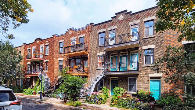
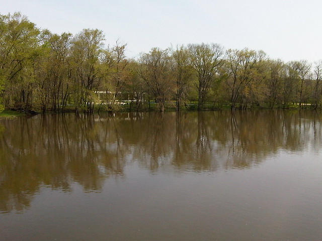
The Planning Fetish: Comprehensive Plans
A guest post by Jennifer Hurley AICP, CNUa, PP, sent via channels affiliated with CNU NextGen. Although I didn’t write this, I agree wholeheartedly based on my experience working in several cities with varying degrees of commitment to comprehensive planning.
Planners have a fetish about comprehensive plans. Their belief in the power of comprehensive plans and their obsession with creating comprehensive plans illustrates what anthropologists call “magical thinking.”
Comprehensive planning as taught in most planning schools is a failed institution. I’ll pause for the collective gasp. Unless required by state law, most communities undertake a comprehensive planning process rarely, if ever. For years, planners have bemoaned this state of affairs—if people only understood what we do and how it benefits them. To address the lack of interest in comprehensive planning, planners have taken a marketing and education approach, trying to persuade people that we have a product they need.
But the market is telling us something. Maybe we should listen. If comprehensive plans were truly useful and a good return on investment, communities would presumably clamor for their creation. So why don’t communities “do” comprehensive planning?
Comprehensive Planning is too expensive. Being thorough in scope, data analysis, public participation, policy formulation, and urban design is incredibly expensive. It takes a great deal of technical expertise and time. Only a few communities can afford to do it at all, and even those only occasionally.
Comprehensive Planning is exhausting. In addition to the expense and exhaustion, comprehensive planning is no fun. Planning staff, public officials, and the public experience burnout. Once they complete the plan, they don’t want to touch it again for years.
Comprehensive Planning is not effective. Most comprehensive plans sit on a shelf rather than motivate people to action. The thoroughness of comprehensive plans means that few people have the time or attention to read the document, and no one uses it as a ready reference. Planning Departments often specify in Requests for Proposals that they want a plan that is “implementable”, gets used, and does not “just sit on a shelf.” They know what they do not want, but they do not know what to ask for in its place.
How can planners overcome these weaknesses in conventional comprehensive planning? The answer lies in understanding “plan” in its verb form rather than its noun form. The “plan” itself is simply a byproduct, not the most important outcome, of good planning. The most important task of comprehensive planning is to develop extensive understanding and not just to include everything and the kitchen sink.
Planners can provide value, improve the communities in which they work, and raise the profile the planning profession by focusing on three basic aspects of good planning.
Visioning: A community, group, organization, etc. needs a shared vision of the future they hope to reach. A vision is what people see when they can imagine that all of the constraints of today have fallen away. The community’s vision is not merely an amalgamation of many individuals’ visions, but something larger that individuals uncover and build together through group efforts. A concrete, articulated vision gives people a goal, a collective sense of direction, and a reason for moving forward through hard work. Achieving that specific vision is not important; in fact, the changing environment almost guarantees that any vision we articulate today will be out of date in the time it takes to achieve it. What is important about the vision is the motivation and collective goal it provides.
Relationship & Community Building: Community and the relationships that make up community comprise the living, breathing organism through which we carry out action. We need to leverage our targeted, short-term planning processes and interventions to build stronger relationships, healthier communities, and organizational capacity. The effects of a planning process reverberate through an area for years, possibly decades. Long after the specific details and data are obsolete, the quality of the experience, the institutions nurtured, and the relationships built through the process shape the future.
Strategic Action Planning: Strategic Planning involves analyzing various aspects of the environment, including physical, social, economic, political, etc., to evaluate how they affect realization of the vision. Action Planning creates a vital roadmap for immediate next steps. Putting one foot in front of the other, over and over again, is the only way things get done. The institutionalization of repeated rounds of Strategic Action Planning transforms planning from its noun form (an occasional process resulting in a static product) into its verb form (an ongoing method for acting in the world).
The world needs planners and planning. We owe it to the communities in which we work to provide effective planning. We cannot allow our blind faith to deprive the world of good planning.
Map: mortgage interest deduction underwrites suburbs
See those donut holes? Inner-city areas with low rates of homeownership, low incomes (and thus fewer residents who itemize deductions), and relatively lower property values are receiving far less of America’s fattest housing subsidy — the mortgage-interest personal income tax deduction (see previous discussion) — than their better-off suburbs. The sprawl subsidies continue apace.
The bigger picture is that this is a subsidy that overwhelmingly benefits wealthy people who have expensive houses, and big mortgages to match — and thus benefits “coastal elites” more.
Map from the Pew Center on the States’ report “The Geographic Distribution of the Mortgage Interest Deduction” (PDF).
War or not, it’s working
“…because the mayor hasn’t declared a war on cars. I doubt that anyone disagrees that we need to reduce traffic. I would call it an effort to get people to use alternative transportation.” – Mayor Vincent Gray, 20 February 2013
Okay, so I think we’ve established that there is no war on cars. But call it what you will, “efforts to get people to use alternative transportation” do seem to be working quite well, as steep declines in people using cars to get to work (lighter lines) are declining vs. people using “sweet modes” increases (from MWCOG research):
One net result is that the doom-and-gloom traffic apocalypse predictions are now no longer valid. Even if VMT resumes its 40-year upward track — an exceedingly unlikely occurrence given recent trends — the past several years of flat or declining VMT has permanently dented the total, and therefore the amount of road space needed in the future (from OSPIRG):
Driving is not coming back. It’s time to get used to it.
Signals across the urban archipelago
A recurring theme that I keep hearing about in 2013 is that cities — linked together through national and global networks — must assert a leadership role in conceiving and implementing the policy changes necessary to adapt to the 21st century. Not only have these changes become too great to ignore, but the federal government that led America through the last great era of socioeconomic upheaval (the consolidation of the United States into the world’s industrial superpower) is mired in deep paralysis. Although states are meant to be the “laboratories of democracy,” they suffer from the same hyper-partisan paralysis and an institutional bias against metropolitan regions.
As a recent Economist editorial put it: “the rest of the country is starting to tackle some of its deeper competitive problems. Businesses and politicians are not waiting for the federal government to ride to their rescue… Pressed for cash, states are adopting sweeping reforms as they vie to attract investments and migrants… creative policymaking is being applied to the very problems Congress runs away from, like infrastructure spending.”
Taking a cue from a sharply partisan 2004-election postmortem by Dan Savage and the editors of The Stranger, we live in an era of The Urban Archipelago:
If Democrats and urban residents want to combat the rising tide of red that threatens to swamp and ruin this country, we need a new identity politics, an urban identity politics, one that argues for the cities, uses a rhetoric of urban values, and creates a tribal identity for liberals that’s as powerful and attractive as the tribal identity Republicans have created for their constituents…We’re going to demand that the Democrats focus on building their party in the cities while at the same time advancing a smart urban-growth agenda that builds the cities themselves. The more attractive we make the cities–politically, aesthetically, socially–the more residents and voters cities will attract, gradually increasing the electoral clout of liberals and progressives.
This approach was plainly evident in the closing panel at NACTO’s Designing Cities conference, where as Angie Schmitt reports, “transportation chiefs from Boston, Philadelphia, San Francisco, Chicago and New York all talked about the progress their cities have made and shared their frustration at the lack of attention to cities and transportation in the state and national political arenas.”
“Why aren’t state governments and Congress keeping up with cities? Chicago DOT Commissioner Gabe Klein proposed that it’s because city residents — especially younger residents and entrepreneurs — expect their mayors and city governments to move at a much, much faster pace. City governments have to be much more creative and nimble to respond to these demands or else risk losing the residents and businesses that power their economies.” Yet, that agility doesn’t extend to the federal level: as Randy Neufeld said, “the disconnect seems to be Congress being out of touch with the good stuff happening on the ground.”
At the conference’s opening keynote, USDOT secretary Ray LaHood bemoaned that he would have preferred to do even more to support local government innovation, but that Congress had always “taken care of our infrastructure needs, right up to this moment in history” — indeed, singling out “this particular Congress,” which has a peculiarly awful track record at passing transportation legislation.
As further proof, the bond analysts at S&P agree with the overall devolution trend, reports Ashley Halsey in the Post: “The burden to finance infrastructure projects will fall more heavily on local government entities or users in the form of higher rates or tolls.”
A natural follow-up to the NACTO meeting came at TRB a few months later, where Bruce Katz addressed a substantially similar crowd at the Transportation Issues in Major Cities committee meeting. In summing up his forthcoming book, he strenuously argued that federal government are paralyzed by dysfunction, states refuse to adapt to the new metropolitan reality (and indeed, many state legislatures are backsliding), and need to be bypassed if cities are to successfully adapt to new global realities. The good news is that cities are in fact stepping up — even though they usually haven’t been empowered to do so.
(This comes with a huge caveat: ultimately, even a paralyzed state is a sovereign unit — quite unlike a city, whose municipal charter [particularly in a Dillon's Rule state] may be tremendously limiting. And it is much more difficult to do a 50-state campaign, or even a 20-state campaign, than a single national campaign.)
How can citizens and local government officials respond? We can set up peer-to-peer innovation networks so that innovations can spread more quickly and easily between cities. States and national governments can no longer be counted on to scale up innovations, but we also no longer need them to do so.
We won’t be able to innovate our way out of every intractable problem, but a fresh understanding of the problems, we may be able to find new resources to bring to bear. For example, Janette Sadik-Khan summed up her department’s super-effective work in three broad steps:
1. Leveraging existing assets: a holistic approach to street space manages to do more with less; “back to basics” means that feet come first; local & state governments already spend $2 in general funds on transportation for every $1 in road user fees and should expect greater accountability
2. Working nimbly: in times of austerity, we can’t afford not to work smarter, not harder (echoed by Rina Cutler from Philadelphia as “we cannot not fix” urban infrastructure, and by Gabe Klein, who contrasted the old capital-intensive approach with new ways that resemble “marketing, change management, public relations, and sales”)
3. Transforming the city: Mayor Bloomberg noted that the city has surpassed records for population & GRP, but has experienced the safest five-year period in its history and has successfully directed all new travel demand onto transit.
(About the title: a friend of mine grew up in Windward, the collection of damp suburbs east of Honolulu. There, TV and radio signals from Honolulu, just five miles away, are blocked by a mountain range, so instead residents watched TV from Maui, a hundred miles away across the flat ocean. Such is life in an archipelago: sometimes we have more in common with people far away than those just on the other side of the ridge. Our cities have more to learn from one another than from their hinterlands.)
Parks are free, right?
And this month’s award for Not Getting the Point goes to:
“The idea that McMillan could be Washington’s Millennium Park or High Line, that kind of creativity has never come to the project,” [John] Salatti [of Bloomingdale] says.
Not only does he want a free park instead of taxpaying development on a decrepit old industrial site that the District needs to develop to meet its own revenue projections. Not only that, but he wants a park on par with two fabulously expensive parks: $475 million and $250 million apiece just for construction, plus ~$9 million a year apiece in maintenance, and all even though his neighborhood is a half-hour stroll from the National Mall, which is not only about as big as Grant Park and Central Park combined, but might have a few world-class attractions of its own.
No, the real stupidity lies in his ignorance of park financing. Both of those parks were largely paid for by lining said parks with skyscrapers: Millennium Park with revenue from the Central Loop TIF, bolstered by 80-story towers that boast park views, and parking garages underneath it that serve the adjacent downtown; the High Line only became possible by selling its underlying development rights and upzoning some adjacent areas by 50% to permit residential towers in an industrial zone.
Diseases of affluence cured by…
removing affluence, of course. Or, put another way, saving money can sometimes save lives.
Population-wide interventions (in this case severe austerity) reduced chronic disease burden in the very unique case of Cuba’s “special period,” an economic catastrophe that struck a society that is peculiarly undemocratic, resilient, and underpinned by strong public health resources (and thus has excellent data). From Richard Schiffman in The Atlantic, summarizing an article by Manuel Franco, Usama Bilal, et al in BMJ:
that the health of Cubans actually improved dramatically during the years of austerity… based on nationwide statistics from the Cuban Ministry of Public Health, together with surveys conducted with about 6,000 participants in the city of Cienfuegos, on the southern coast of Cuba, between 1991 and 2011. The data showed that, during the period of the economic crisis, deaths from cardiovascular disease and adult-onset type 2 diabetes fell by a third and a half, respectively. Strokes declined more modestly, and overall mortality rates went down… The Cuban experience suggests that to seriously make a dent in these problems, we’ll have to change the lifestyle that helps to cause them. The study’s authors recommend “educational efforts, redesign of built environments to promote physical activity, changes in food systems, restrictions on aggressive promotion of unhealthy drinks and foods to children, and economic strategies such as taxation.” [...] If the United States want to stem the rise of diabetes and heart disease, either we get serious about finding ways for to become more physically active and to eat fewer empty calories — or we wait for economic collapse to do that work for us.
The authors (and I) do not condone replicating the Special Period crisis, but as a data-collection exercise it is unique in providing a look at the effects of unprecedented, population-scale, sudden change in both diet and exercise. The primary cause of removing fossil energy had a secondary effect of removing food energy from the economic system, as well, and increasing its expenditure to make up for the lost fossil fuel. The accompanying video (at the BMJ site) has interesting graphs of how the entire population’s BMI shifted both during and after the Special Period.
Walking to DCA, and driving away
[Part of an occasional series of FAQs about traveling to Washington, D.C. For more, please click on the "dc-faqs" tag above.]
For those arriving/departing DCA on beautiful days like today, you might be interested in walking or cycling (perhaps using the marvelous Capital Bikeshare system) to DCA. It’s not just possible, it’s really pretty easy and fairly well signed. Indeed, it may be America’s most pedestrian friendly major airport. Note that there are multiple approaches, depending on where you’re coming from and where you’re going.
Where you’re going:
Concourse A is at the south end, Concourse C is at the north end, and B is closer to the north. Higher gate numbers are north.
As of this writing, US Airways is at the north end (C/B), American and Delta and United in B, and everyone else in A.
Where you’re coming from:
1. From northern Crystal City, via the Mount Vernon Trail access at the Water Park/18th St. S., this map shows two route options:
The yellow route is the signed route from the Mount Vernon Trail, without any grade crossings. It’s reasonably direct for cyclists approaching from the south, but for pedestrians from the north it adds almost 1/2 mile (and even more for people headed to the south pier or Terminal A).
The red route is much more direct for those coming from Crystal City (to the north) but requires jaywalking across a three high-speed roads, each one 1-2 lanes and with okay sight lines.
2. From southern Crystal City, or for the south end of the airport (Terminal A, south parking garage & car rentals), start at the sand volleyball courts and walk along the northbound exit ramp, over the Airport Access Road bridge, and follow the signs around the offices to the terminal.
3. From points north along the Mount Vernon Trail, like Rosslyn and D.C., you can also exit the Mount Vernon Trail into the airport employee parking lot at the airport’s north end. (There are usually US Airways Express regional jets parked behind the fence here, right next to the trail.) Just follow the sidewalk alongside the airport offices to Concourse C.
4. From points south along the Mount Vernon Trail, the trail directly crosses a spur to Aviation Circle at the airport’s south end, by the Signature Flight Support building. Just exit the trail there and head north along Aviation to the concourses.
Once you’re on airport grounds, there’s adequate signage along the walkways, several outdoor bike racks, and a shuttle bus connects the concourse curbsides, rental car center, and Metro entrance. In most cases, walking is just as fast as waiting for the shuttle.
Driving away
DCA’s easy accessibility opens up another multimodal possibility: car rentals. In particular, Hotwire and CarRentals.com weekend-special rates from DCA can often be found for around $10-15 (+ required fees = $30); these rates are generally available Friday morning to Monday morning, and sometimes at the last minute on weekdays.
If you prepay online, check-in takes a few minutes at an automated kiosk, and the cars are parked upstairs; the entire process takes about 10 minutes. The car rental center is in the south parking garage, across from Concourse A and near the south exit of the Metro station.
Flying in: the river visual approach
The flight approaches to DCA fly over the Potomac River, in order to avoid noise impacts over the city and to avoid flights over “P-56″ (aka the Monumental Core). If winds are from the south/east, flights will land from the north and take off to the south. Planes are closer to the ground during landing than during take-off, so if you have this landing you’ll be treated to fantastic views of central D.C. (on the left side) and Arlington (on the right side) in the last few minutes of flight.
As a planner, I find it fascinating to watch the cityscape unfold:
- the topographical shift, from hilly up by Great Falls through to Georgetown, then the coastal flats below
- the formal straight lines of the Mall and L’Enfant Plan, reinforced by the dense built fabric, and on the other side the curves of Arlington Cemetery and its riverfront roads
- tracing the lines of activity and development along roads like Wisconsin and Connecticut, and the Metro subway lines
- the D.C. skyline of public monuments and churches, and how close planes fly to Rosslyn’s office towers
- further out, the clear distinction between preserved farmland in Maryland and suburban sprawl in Virginia


