Openings: retail possibilities at Union Station, Metro Center

Two recent retail news items in downtown DC reported by Jonathan O’Connell in the Post:

Union Station, East Hall

B. Smith’s, the restaurant inside the former State Reception Room (Presidential suite) at the east end of Union Station, has announced its imminent departure.

The managers of Union Station have done well re-merchandising the West Hall with popular quick-casual restaurants in recent years: its current tenants include Chipotle, Chop’t, Potbelly, Roti, Yo Sushi, and now Shake Shack (perhaps in the vacant America! restaurant space). It’s true that the West Hall offers a superior location astride the path between the Metro entrance and the Great Hall, whereas the East Hall (pictured above with its jewelry kiosks) was always a cul-de-sac — for obvious security reasons, the State Reception Room was secluded. The odd thing is, the West Hall was historically just a ticket lobby (see old floor plan here or current floor plan here); the East Hall that was purpose-built for foodservice:

Union Station Dining Room

(This and other great vintage postcard views of the various rooms inside Union Station are featured in this Streets of Washington post.)

Imagine how well the space would function if the present-day retail uses were flipped: the East Hall returned to dining, anchored by a new fine-dining restaurant in the State Reception Room and perhaps another within the old Lunch Room (now the Columbus Club on the mezzanine, and Lost City Art on the main level), the West Hall for high-traffic retailers, and an anchor tenant filling the vacant theater and the eastern half of the food court. (Current plans for adding escalators indicate that there’s at least 40,000 square feet available downstairs, between the vacant 32,000-foot theater and 8,000 feet where the existing food court widens to the south.) As it stands, though, I have a hard time imagining a new merchandising plan for the East Hall.

Elsewhere in downtown, Target has considered opening a CityTarget location at 555 12th, the former ESPN Zone space. Having never been inside, I wasn’t aware of how vast the site is, but broker CBRE has a great diagram: there’s 59,000 sq. ft. vacant (12,000′ on the ground floor + 47,000′ on two basement levels). CBRE is also soft-marketing the 32,000′ that Barnes & Noble rents on the ground & second floors; as great as it is to still have a bookstore downtown, B&N’s upstairs is pretty woefully underused these days, and their lease expires soon. The office market in downtown DC has historically been so strong that retail spaces of this size (e.g., Woodie’s and Hecht’s) have usually been converted, leaving few suitably large retail spaces available.

Still, it’s going to be a squeeze. The smallest CityTarget today is 75,000 sq. ft. in San Francisco, although on a recent earnings call (h/t Thomas Lee at the Strib) CEO Gregg Steinhafel noted that “we have the ability to reduce space even more, allowing us to further shrink the size.” Then there’s the verticality: OK for a restaurant or a bookstore, but 4 floors may push the practical limits for shopping carts: cart escalators eat both time and square footage. (Target operates many 2-floor locations and a few converted 3-floor department stores in Southern California.)

Transit creates value, case study: Las Vegas

Las Vegas Monorail (1851)

Years ago, I dissed the Las Vegas Monorail, which eventually did flame out in a spectacular bankruptcy. Per Howard Stutz in the LVRJ: “a two-year-long bankruptcy reorganization wiped away more than 98 percent of the transit system’s debt.”

Yet the monorail is still up and running — it’s worth more that way than as scrap* — now that it doesn’t have to pay back its capital costs (which no transit system could feasibly do just from operations). Management can now think more strategically about how the monorail adds value. Far more than just a novelty ride, the system “has relieved traffic congestion on Paradise Road when large conventions are in town,” and as such “[CEO Curtis] Myles said the monorail company is hopeful for more Strip support.” In other words, even in Vegas, the usual economics apply: transit doesn’t make money for the people who run it, it makes money for the people around it (landowners and people traveling in the corridor regardless of mode), whether or not they’re actually paying for it. If those people aren’t paying into the system through taxation, they’re free-riding (so to speak).

Not surprisingly, research by Daniel Chapman and Robert Nolan on the value of transit finds that it spins off significant value from agglomeration economies. Transit moves people, to be sure, but more importantly it creates places: all transportation is ultimately a means to an end, but transit enables the creation of super-profitable large agglomerations, throughout a metro area: “A 10 percent expansion in transit service (by adding either rail and bus seats or rail miles) produced a wage increase between $53 and $194 per worker per year in the city center. The gross metropolitan product rose between 1 and 2 percent, too.”

Joel Garreau said as much in Edge City (!) all those years ago, that transit can, at the margin, add just enough population to push a mediocre agglomeration of offices into the realm of a “nice” place. What we didn’t know then was just how much more profitable that “nice” factor was.

* Interesting tidbit: even in the midst of WW2, when scrap metal prices were at what must have been a relative record, disassembling the ruined Tacoma Narrows Bridge cost more than the scrap metal was worth.


In local news, Daniel J. Sernovitz at WBJ covers what might genuinely be a historic parking spot, worthy of commemoration but perhaps not preservation (I mean, a parking spot is a parking spot).

The river flooded my walk shed (2)

Large station footprints (covered earlier) pose a particular problem for surface transit modes with wide geometries: as with the expressway-interchange station I ridiculed then, the infrastructure grows to a scale so large that it dwarfs pedestrian circulation to/from the station.

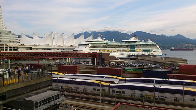
Wide geometries particularly hurt the utility of water taxis, which rarely prove truly practical in modern cities. Boats have very wide geometries and require deep-water docks far from shore, usually half of the walk shed is wasted on water, and high-intensity land uses and high-capacity transportation connections are usually set far back from flood-prone shorelines. Thus, even North America’s busiest transit ferry (Vancouver’s SeaBus) is separated from the street by 300m (~1000′) of walkways:

today's office view

Thus, the ferry’s 400m/five-minute walk shed is limited to just one block beyond the station itself:

Water taxi 5-minute walkshed

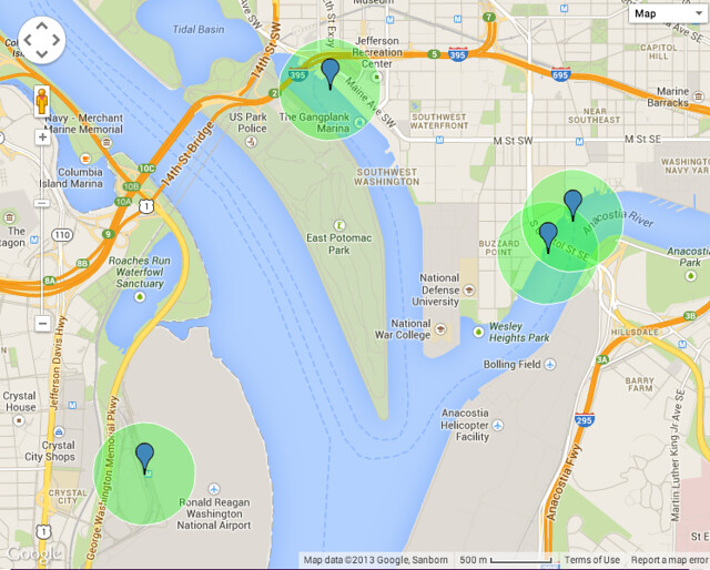
David Alpert recently suggested Vancouver-style ferries along the Anacostia, but the geometries of both the ferries and the waterways make this difficult. Even though I probably live closer to a water taxi dock than just about anyone else in D.C., I have yet to come up with an occasion to take the existing water taxi service — it’s super slow and doesn’t go anywhere useful.

Water taxi 5-minute walkshed

Because of Greenleaf Point (Ft. McNair) and Hains Point, the distances between the docks are much further via water than they are via land: the Wharf has an enticing waterfront, but it’s on the nautical equivalent of a cul-de-sac, 1.5+ miles away from the main stem of the Potomac. Thus, Wharf-Georgetown is twice the distance by water as by land, and thus it’s much faster to walk or bike between all of the water taxi stops. Even once riverfront sites like Buzzard Point, Poplar Point, and Reservation 13 get developed, the Anacostia Riverwalk Trail will be much more important as a mode of transit: it’s that much closer to land-side destinations, and available on-demand, 24 hours a day.

Ferries are slow compared to land travel: 30 MPH is “fast” in nautical terms, and 40 MPH is “high speed.” Thus, 1.5 miles means a 10-minute roundtrip time penalty just to get up to the dock, plus the not-inconsequential time spent actually docking. Ferries are surprisingly fuel-inefficient, since water displacement sucks up a lot of forward momentum.

What’s more, the landside transportation capacity isn’t really there most anywhere along local rivers. The walk shed from any ferry extends only 1-2 blocks inland (see the 400m walk sheds from Georgetown waterfront and Kennedy Center docks), and along most of the Potomac or Anacostia that space is taken up by highways, parkland (in the shallow tidal rivers), or steep hills (in the Potomac Gorge north of Roosevelt Island). Even in Alexandria, the quintessential port town, and at National Harbor, most of the activities and transport connections are set well back from shore. Just because a lot of things exist vaguely near the Potomac doesn’t matter, if the last-quarter-mile connections are awful. Already, we have lots of local examples of under-used transit that gets you sort of close to things, but not door-to-door.

Water taxis come closer to being time-competitive in situations like in Chicago, where land traffic congestion is appreciable and major activity centers like the railroad stations are within 200′ of the river — but where the river usually sits well below the (elevated) level of the streets around it. I’m hard-pressed to find many other examples in the USA where similar conditions exist, though.

Help, the station ate my walk shed (1)

Part 1. How 400 meters becomes 100 meters

Armitage

When I lived on West North Avenue (the namesake of this blog), I could walk out my front door, hear an “L” train approaching from behind the apartment, dash across the street and around the block, and catch said train at the station a block away. When I recently asked Chicago friends about how much time it took for them to travel through their “L” stations, the responses were quizzical: “Uh, seconds?” “Less than a minute on either end. Perhaps you should be measuring in seconds.”

Wheaton Metro escalator

The Washington Metro might have record-smashing escalators and awe-inspiring cathedral ceilings in place of the L’s humdrum wooden platforms, but the sheer size of its stations hurts its usability for short trips, writes Ian Rasmussen:

“You’ll almost never hear about how long it takes to get from the street to the platform when people are telling you how long a transit trip is going to take… [I]n the context of systems designed to attract longer trips (30, 40 minutes), it hardly matters. But in the case of shorter trips, such as those in the urban core where the system is intended to act as a circulator, the issue cripples the system… just think of how you feel waiting to get off an airplane when you are about to miss your connecting flight.”

When combined with shameful 20-minute headways, the two or three minutes* it takes to descend to, or emerge from, a Metrorail platform add up to a substantial fixed time penalty on short trips within the core. It isn’t just the flowing mezzanines and interminable escalators, either: even in dense residential neighborhoods, stations often empty into meaningless plazas rather than seamlessly meeting the neighborhood. Over time, buildings will grow towards the station (as at Columbia Heights), but this process takes decades and has often been stymied by poor planning decisions.

Potomac Ave

This is not to absolve Chicago: it arguably invented the expressway median transit line and thus spawned places like Rosemont — which Yonah Freemark called “the Land of Missed Opportunity” for its uniquely awful transit-adjacent development pattern. The town of Rosemont** obviously understands that its “L” access gives it a valuable advantage over more distant suburbs. However, its station area pedestrian experience is just monumentally bad, with an uncharacteristically lengthy “L” station emptying out into a bus parking lot in the middle of an interchange. The net result: absolutely nothing, besides said bus terminal, is within the five-minute walk shed (below). Rosemont has attempted to compensate by subsidizing all-day circulator shuttles to feed its new retail/entertainment hub, but no shuttle can match the spontaneity of a quick lunchtime walk.

Rosemont "L" walk shed

Expressway median stations suffer from a triple whammy of poor geometry:
1. The geometries of the surrounding environment are often defined by the 70 MPH cars swirling around them (particularly since the busy streets that make sense for station entrances also make sense for land-gobbling interchanges), rather than the 3 MPH pedestrians within;
2. Much of the walk shed is wasted crossing the freeway itself, much less interchanges;
3. The adjacent land uses either want to shy away from the freeway’s noise and smoke, or surround themselves with moats of parking and limited access routes, or both.

The same geometric problem is hardly intrinsic to rail. Bus rapid transit, which essentially is the interface between a highway for heavy buses and pedestrians, faces exactly the same problem. Here’s the award-winning system in Guangzhou:

Guangzhou

The service had better be really fast, and really frequent, to be worth braving all that just to get to the bus stop. This sort of grade separation (also seen in Ottawa) is unusual; cost containment usually leaves pedestrians running in front of buses at grade, as in Cleveland:

Euclid at PlayHouse Square

Many of the inexpensive freight-rail alignments used for recent light-rail projects suffer from a similar (although less extreme) distance from the urban fabric. The north end of Baltimore’s light rail line runs in the former Baltimore & Susquehanna (B&S) Railroad ROW north to Timonium, alongside a stream valley, separated from adjacent development by buffers, grade changes, woods, and (to the east) the Jones Falls Expressway.

P1080461

The LRT corridor passes many major activity centers on the north side of Baltimore, including two campuses of Johns Hopkins University, parks encompassing the stream valleys and adjacent hills, the Woodberry area of redeveloped mills, prosperous neighborhoods like Hampden and Roland Park, and at the northern end the backs of retail and business complexes facing York Road in the northern suburbs. However, historically development of residential and retail uses focused on the hills above the stream valley and freight railroad; the only uses directly fronting onto the railroad today are station access uses and some renovated mills. Jeff Wood notes that Minneapolis is about to embark on a similar mistake with its Southwest LRT project.

In short, to genuinely intertwine transit with city life, it has to be as close & convenient as physically possible. Don’t cheap out on an inexpensive but inconvenient alignment, don’t over-engineer stations, and seek the smallest possible station footprints that will do the job. These principles should seem obvious, but too many new transit projects still don’t get this interface right. I’ll explore some more examples in two future posts.

* Times measured at Rosslyn and Court House.

** For those unfamiliar with Chicago, Rosemont has leveraged its unique location surrounded by the city’s transport links (airport, freeway, beltway, transit) to suck “profitable” airport-adjacent offices & hotels from a city that warehouses its low-wage workforce. Therefore, it’s the quintessential parasiticaffluent job center.” [OK, slightly strange link, but I couldn’t find any other summary of Myron Orfield’s Metropolitics suburban-town typology that was in HTML rather than PDF.]

Jefferson tries Streetmix

In 1803, Thomas Jefferson suggested to D.C.’s government that the broad Pennsylvania Avenue be lined with trees, in the manner of the elegant French gardens that he admired. The original street-section schemes, drawn by Nicholas King, are in the LOC’s collection, and thanks to Streetmix I’ve taken the liberty of updating them to imagine how they’d have evolved since then. Today’s configuration of Pennsylvania Avenue NW has wide sidewalks and double/triple rows of trees, and was designed and redesigned by various urban renewal commissions from the Nathaniel Owings Plan of 1964 through the the PADC up into the mid-1990s.

Option #1 was the then-road, a narrow dirt path.

Jefferson's Pennsylvania Ave #2
Option #2 has a center gravel passage for horseback riders (today, cyclists?) flanked by two carriageways. I’m not sure how many roads of the day separated solo horse riders from carriages; perhaps the idea of having a separate center track was because an unburdened horse could travel considerably faster, and therefore should stay to the left of carriages. Nonetheless, the idea of a center track isn’t exactly new.

Jefferson's Pennsylvania Ave #3
Option #3 has a broad carriageway flanked by two gravel footpaths, here reinterpreted as tree-lined cycletracks. Although this carriageway looks far too wide, today’s asphalt expanse is pretty much this wide — and ensures a relatively clear vista down the middle towards the Capitol (and Treasury, I guess).

Jefferson's Pennsylvania Ave #4
I’ve illustrated Option #4 with a center transitway, although that seems like it would result in many conflicts between pedestrians/transit riders and cyclists.

The lights aren’t broken, but the design is

Uplighting by Payton Chung
Uplighting, a photo by Payton Chung on Flickr.

L’Enfant Promenade is so badly designed that it accomplishes the rare feat of making something darker by applying light. Lots and lots of lights, actually, which instead of illuminating the street surface instead just spill their coal-fired power as light pollution. This is just one of many things about this streetscape that are objectively wrong, as described by GGW commenter “Moose”:

L’Enfant Promenade is miserable. I work down there, and it’s too hot in the summer, too cold in the winter. No vegetation to help mitigate the effect of the wind canyon created by the buildings. The paving stones they used for both the road and the sidewalks are rough, and difficult for bikes and pedestrians. The “lights” they have on it don’t shed enough light at night to actually illuminate the sidewalks or road, but they do put out enough light to not let your eyes adjust to darkness (when they’re not blinking on and off, that is – there seems to be a short in the sensor or switch used to turn them on at dusk).

Yet somehow, the notion that this could be a landscape worthy of immortality (a supposedly rare privilege, as it places stewardship obligations upon future generations) actually exists out there in someone’s brain, and therefore tax money needs to be spent investigating that specious claim (perhaps at the DC Historic Preservation Review Board, if the GSA is to be believed about claims regarding Banneker Circle). Perhaps not since the SF Bike Plan has such a quantity of money been spent for planners to prove the obvious.

It’s no better by day, either. Nor is our jaundiced view just because it’s one generation old; it was hardly beloved even when it was shiny and new, if press and eyewitness reports are to be believed.

L'Enfant Promenade

Thankfully, this 1980s bulbs-and-brass interior was recently ripped away because again, it was objectively wrong — it never succeeded at being attractive, otherwise the shops around it might have done okay. Otherwise, surely someone would rush in and “rescue” it with some obviously-well-deserved historic protection.

Time warp

Two steps to a longer life

North End

1. Walk: “Time spent walking, then, is utterly free. It’s time you would have spent dead.” [Alan Durning]

2. Better yet, wander. Peter Bosselmann writes in Urban Transformation that complex routes feel longer, more enjoyable, and more satisfying. The study design used two short routes on the Berkeley campus of the same length, the same time, the same climb, the same number of passerby: one up the City Beautiful mall, the other winding behind the same buildings. Bosselmann quotes William James’s 1892 text on Psychology: “A time filled with varied and interesting experiences seems short in passing, but long as we look back. On the other hand a tract of time empty of experiences seems long in passing, but in retrospect short.”

(The discussion is on pages 187-189, citing Emelie Cheng and Yu Cao, “Time on Campus: A Study of Visual Elements,” 2004, and a map of the two routes is at Planetizen.)

Park[erings]plats, flat-packed kit edition

Park(ing) Day furnished by IKEA

The new IKEA catalog includes this reminder that there are now just 52 shopping days left until Park(ing) Day 2013 on 20 September. Having documented a few similar installations in the past, I’ll say that the practiced tiny-room-builders get these elements right:

  • Floor: define the horizontal space with “symbolic groundcover.” A large green rug is great because it’s relatively light and quickly rolled out, but for reuse purposes, keep in mind that it might get dirty. I tried hauling remnant sod to our site, but it turns out that live plants are terribly heavy. Even lighter-weight: chalk!
  • Walls 1: stake out the corners with vertical elements. Not necessarily as high as the fabric screens shown, but enough to…
  • Walls 2: structure the space so that the “backs” face cars and the “front” faces the sidewalk. They could have done a better job with sheltering the street face of this one, but that would’ve blocked the camera’s view in.
  • Ceiling: define the space above with a shading element; the umbrella shown is again a very lightweight answer.
  • Weight: A temporary installation should be literally lightweight and easy to pack in & pack out — particularly if you’re committed to a car-free Park(ing).

That said, it’ll cost more than $320 to furnish a Park(ing) Space at IKEA: a typical American parallel parking space is 9′ x 20′: large enough for four of those HAMPEN rugs, laid perpendicular to the curb, not just one laid parallel. Also, this seems like a great chance to show off some of their outdoor collection: a potted tree on a plant stand, for instance.

More resources: the official Park(ing) Day Manual, plenty of photos, and even more Flickr photos.

Red light cameras: another false “controversy”

[On deadline this week & next week, so no grand posts for now. Instead, here’s something I adapted from an online argument about red light cameras. However, I do have some meaty posts on their way.]

I know that red light cameras aren’t popular, but (1) car crashes kill about as many Chicagoans each year as murders, and many more in affluent areas; (2) the consensus of peer-reviewed research [e.g., Bochner & Walden, ITE Journal 80.5; Persaud et al, TRR 1922] shows that RLCs are significantly effective at reducing crash severity. Yes, the number of rear-end crashes increases, but the number of right-angle crashes declines by more, and those are much more severe crashes: not only do they occur at higher speeds, but directly impact the passenger cabin. RLCs would be a good investment in safety even if they did not pay for themselves.

The popular press has a way of taking a peer-reviewed study, and quotes from actual experts, and “for balance” contrasting those with quotes from less rigorous research or just base speculation. In this particular instance, the contrasting study is not peer-reviewed, does not consider crash severity, and likely doesn’t pass statistical significance.

It appears that the popular press more broadly is fabricating evidence against RLCs, appealing to readers who want to absolve themselves of responsibility for their poor driving habits (and dodge the accountability that RLCs provide). People don’t like to be reminded of the horrific consequences of driving, after all.

July shorts: aimless bicyclists, green roofs

Pearl St.
Do the French have a term for aimlessly bicycling around towns?

Cleaning out the fridge, so to speak, with several links & quotes:

1. Flaneur, randonneur: just wandering about, whether on foot in the city or on bike in the countryside, is a long-established practice in French but just doesn’t translate to English.

There’s no direct translation for randonnée (pronounced ran-don-NAY) — it can mean a long outing or trip, or a ramble in the countryside. For its practitioners, called randonneurs, it’s easier to define the event by what it isn’t: a race. There are time limits, which means riders can’t go too slowly — but they also can’t go too quickly.

2. Mayor Bloomberg speaking about the myth of the scofflaw cyclist at Citibike’s launch:

I’m sure there will be people who will, just like they are today, take their bicycles and do things that break the law. This will shock you but there are even people in automobiles who do the same thing. When you take a look at the number of people killed in automobiles, it sort of dwarfs everything put together on the road.

3. The world is filled with ironic NIMBYs, but this story still takes the cake: a retired Concorde pilot complaining about the noise from a playground.

4. Nate Berg sounded an appropriate note of skepticism over green roof cheerleading. It always really irked me that Mayor Daley would take credit for putting green roofs on big box stores in Chicago, even though the ratio of blacktop parking lot to green roof built by said stores is easily 3:1. A garden built on the ground, within a depaved parking lot, can offer more environmental benefits than a monocultural, thin green roof, and at a much lower cost. Oh, sure, someone might lose their parking space, but discouraging driving is yet another environmental benefit!

5. During the years I bike commuted through the South Side, it always fascinated me that Chicago’s ghettos were often bereft of any commerce whatsoever: for the most part, there weren’t even fast-food joints along the way, even though plenty of people lived nearby. Other U.S. cities (much less thriving Canadian inner cities) didn’t seem quite as derelict: witness the busy, if run-down, retail streets of Spike Lee’s Brooklyn. Whet Moser uncovers research by Marco Luis Small that quantifies this: “In some cases, the difference is stark. Chicago has 82% fewer small restaurants, 95% fewer small banks, and 72% fewer small convenience stores than a black poor ghetto in the average city.”

Baltimore to Philadelphia via transit/bike

Border crossing closed

For last week’s holiday multimodal adventure, I decided to try and replicate Josh Kucera’s account of getting from D.C. to NYC solely via local public transit. The Pennsy’s Northeast Corridor is the only corridor in the USA which features local (commuter), rapid (Northeast Regional), and express (Acela) services. It’s not Japan, where some lines feature five service levels, but it’s better than zero.

In particular, I hadn’t yet traversed local routes on Baltimore-to-Philadelphia leg; it’s the most thinly settled part of the corridor, one of the two rail service holes in the corridor (the other is from New London, Conn. to Providence, R.I.), a leg currently served only by Amtrak, Megabus, and Greyhound, since Philly’s Chinatown buses were recently shuttered. Long ago, mostly in the pre-Chiantown bus era, I’d done the local route via SEPTA and NJT from Philadelphia to NYC, which is common enough that the transfer at Trenton is timed and noted on the respective schedules.

My planned route took WMATA’s Red Line to WAS Union, MARC to Perryville, Cecil Transit to Elkton, DART First State bus 65 to Newark, and then SEPTA Regional Rail to 30th Street. The first few legs went off without a hitch; I feared for the tight connection at Perryville, but MARC was a bit early and Cecil Transit probably would have held the bus anyways, as we were the only customers on board.

Where things went awry was near Elkton: DART’s bus map indicates that a transfer is available in downtown Elkton, but the Cecil bus doesn’t actually go into Elkton, sticking instead to the US 40 highway strip. Its last stop is at the Maryland DMV office, just shy of the Delaware border. You’ll have to walk 1.4 miles — there’s a sidewalk most of the way — across the border (pictured above) to the first DART bus stop, in front of a Kohl’s. Once I got there (crusty with sweat), I turned around to see the last DART 55 bus roaring past, several minutes ahead of schedule. With an hour to meet SEPTA, I called in a cab from Newark for the 5-mile, $30 trip to the Newark train station. Had I brought my folding bike aboard MARC, I probably would have been fine skipping Cecil, DART, or both: US 40 seems pretty okay for bicycling, with ample shoulders and even side path signage on the sidewalk in Delaware.

I also pondered routes for biking between Baltimore and Philadelphia, where the most substantial natural obstacle involves crossing the broad Susquehanna River. The Northeast Corridor (no bikes, unless folded or Amtrak-checked), I-95, and the East Coast Greenway all do this just inland from its mouth at Havre de Grace & Perryville. That route has four downsides: MARC would be simplest but doesn’t (yet) run on weekends and doesn’t accept bikes, the Greenway relies on a shuttle service operated by a bike shop in HdG (closed on holidays), MTA’s local buses to Baltimore’s northeast operate only as far as White Marsh Mall, and heavy traffic follows US-40 and I-95. The only other crossing in Maryland, US 1 across the Conowingo Dam, allows bikes but is very narrow, with high-speed traffic. On last year’s Climate Ride, I found the Susquehanna crossing at Holtwood, Penna. to be only slightly frightening.

Since I feel lost when I’m outside the reach of transit, I thus plotted a bikes-and-transit route that heads 40 miles north through Baltimore County (thanks to the UGB set up in the Plan for the Valleys, the light rail terminus at Hunt Valley is at the edge of suburbia) via the Torrey Brown Rail-Trail and York County Heritage Trail to York, Penna., then east through Lancaster to SEPTA’s Main Line terminus at Thorndale. The rail-trail has an accessible grade, and once in Pennsylvania the route runs parallel to the east-west ridges. The transit backup plan exists on Saturdays, when city buses ply much of the east-west mileage from York: across the Susquehanna at Columbia, through Lancaster, east to Cains or Kinzer in Amish country, leaving just 20 miles to Thorndale. On Sundays, Lancaster’s buses still run, but York’s don’t, and SEPTA cuts the Main Line back to Malvern.

Combine that route with a ride back via Holtwood, a trip back via Amtrak or Greyhound (alas, bike-friendlier Chinatown buses and Bolt don’t serve the route), or a tag-on ride to NYC (where you can catch a Bolt back to DC) for a nice weekend adventure.

Dewpoints in DC over the year

Is it really that much more miserable outside in July? Why yes, it is. Here’s a graph of the monthly average, high, and low dew points at DCA.*

Dewpoint range & average at DCA in 2012

High, low, average dewpoint by month at DCA.

Ask people who don’t like hot, humid weather, and they’ll tell you that the weather measurement they rely on most is dew point.

Not temperature. Not relative humidity. Dew point.

“I think it’s catching on,” said meteorologist Paul Douglas. “It a superior way to, at a glance, determine what it really feels like out there.” Bill McAuliffe, Star-Tribune

I’m among those dew point fans. It, not the temperature or the heat index, best describes how it feels to be bicycling here. A hot and somewhat humid day may have a dew point of 70, identical to a cooler and off/on rainy day (of the sort we’ve had a lot of lately), but the net result is still getting drenched in sweat. My guideline for how I’ll feel when stopped (at lights, after riding):
<50 = no sweat, wear regular clothing
60 = nice, maybe change clothes at work
65 = acceptable but pushing it, go slow or get damp
70 = gross with sweat, definitely change shirt frequently
75 = I’d rather it rain, because either way I’m drenched
80 = instant dripping upon setting foot outside, tough to breathe
85 = kill me now, for surely Hades must be cooler than this

Update 13 July 2016: Capital Weather Gang has emoji’d this.

The article gives a good analogy: the dew point is the lowest temperature that it’s possible for sweat to cool your skin down to. I get uncomfortable at 70 and cranky at 80, and that corresponds nicely with the dewpoint guidance above.

The world’s highest dew points are around the Persian Gulf; high temps evaporate a lot of seawater into the air. The Plains and the South get high humidity mostly from plant transpiration.

Being able to ride outdoors without turning into a sweaty mess turns out to be a key determinant of cycling levels: at least one article (Jillian Strauss & Luis Miranda-Moreno, “Spatial modeling of bicycle activity at signalized intersections“) finds that humidity, then precipitation, then temperature determine cycling levels, even in cool Montreal.

This sensitivity to humidity might give pause to bike advocates in the eastern US before taking fashion advice from parts of the world which have very different climates.

In particular, European criticisms of how Americans dress while cycling ignore the reality of our humidity. The average August dew point in Amsterdam? 58F (average monthly temperature is 64F). Their most humid August ever had a dew point of 72F, just above the *normal* dew point here. Of course they dress normally: they can. I spent several days biking around Paris during the catastrophic August 2003 heat wave; it was hot, with temperatures around 100F, but dew points were around 60F. That’s actually kinda nice weather by D.C. standards.

Closer to home, the outdoors/activewear industry is overwhelmingly clustered in the West, which has much more courteous weather than the East or the South. Thus, “soft shell” outerwear appropriate for Cascadian drizzle leaves me drenched within minutes of venturing out into a thundershower, messenger bags pool up back sweat whereas back-saving panniers are hard to find, and everything’s much too casual for a city filled with dark suits.

Most of humanity lives in the tropics, not in balmy Mediterranean or chilly North Sea climates, and it’s about time that fashion recognized that fact. Maybe we should instead take fashion cues from other humid places instead; Japan, Korea, and northern China share both their latitude and westerly continental jet stream with the Northeast and Midwest.

* Bear in mind that these are for entire months, days and nights, and that the high/low numbers are still averaged out over the course of an entire month, so individual days will certainly differ substantially. Also, to the extent that the region has microclimates, DCA probably has the highest dewpoints of the local airports with its low elevation, river frontage, and relatively high urban heat island exposure. Upland areas might be slightly more bearable.

Wunderground

2018 update: Weather Underground’s app includes a “Smart Forecast” feature which lets users set weather parameters for outdoor activities. Foremost for me: moderate winds, and dewpoint below 72, ideally below 61.

Screen Shot 2019-11-17 at 12.03.09

2019 update: WeatherSpark has colorful graphs of dew points through the year for all US weather reporting stations. One in three late-July days at DCA has “oppressive” humidity. Take the Cardinal up into the Appalachians and it melts away; in Staunton, it’s only one in six, and at White Sulphur Springs it’s about one in twenty.