On definitions: equitable communities, magpie infrastructure, vibrant centers, gentrification

Bellevue goes upscale

Bellevue was not one of the “suburban vibrant centers” examined for a NAIOP report on office occupancy trends.

Some recent reports left me appreciative of their aims and ends, but not exactly how they got there, and in particular with how other analyses have defined key terms.

1. The Living Community Challenge certainly provides an inspiring goal to reach for, notably in its use of elegant performance criteria that broadly require “net positive” environmental performance on site — broadly, that new developments can strive to shrink their ecological footprints to fit within their actual footprints. It also pretty seamlessly integrates the Transect throughout, and in a balanced way that sometimes rewards and sometimes penalizes both ends of the spectrum.

However, having participated in the creation of LEED for Neighborhood Developments, it’s telling that some of the same battles in that scheme have emerged within this one. Prescriptive approaches still occur throughout, and some of the personal-health ones are somewhat wishy-washy. (The emerging science of health impact assessments may have been a useful complement here.) The equity section (“petal”) has a lovely intro, but its imperatives don’t address many social criteria — affordable housing is a notable omission — and almost entirely use prescriptive standards. Another long-running debate was over the use of prerequisites in the rating scheme: It seems strange that a baseline, “Petal Community” certification can be done while ignoring a majority (four of the seven) of the petals.

I’ll be interested to learn more about the Challenge in the coming weeks, and to see how others feel about whether it’s rigorous and balanced.

2. Kriston Capps brings up Mikael Colville-Andersen’s term “magpie infrastructure” in a recent CityLab piece. Bicycle and pedestrian infrastructure, examples like the Bloomingdale Trail aside, rarely needs architects’ attention — their structure-first solutions are usually fundamentally anathema to bicyclists’ lazy inclination to not climb hills. By and large, people should be encouraged to stay at grade, and landscape architects and engineers should be entrusted with their care.

Closer to MCA’s home, the current BIG exhibit at the NBM includes Loop City (video; skip to 2:30), a proposal for an elevated rail loop around Copenhagen + Malmo. The proposal lifts up the stations so that trains decelerate on the approach and accelerate as they exit — a clever idea lifted from subways like Montreal’s. When done below-ground, this brings trains closer to the surface just where they’re needed, but when above-ground, the same approach antagonizes the energy needs of the passengers (who need to climb ever-higher escalators to get to the platforms) and the energy needs of the trains.

Another obvious flaw is that the proposal repeats the Corbu-in-Algiers mistake of thinking people would want to live in flats beneath a railway, without realizing that below-the-tracks spaces are almost always only valuable in situations (I’m thinking in Ginza, the Viaduc des Arts, or 9 de Julio) where such space is just the cheapest way of getting valuable ground-level, street frontage. Even maglevs are pretty awful to stand right underneath.

Besides, haven’t we tried grade-separation of different modes before?

3. NAIOP recently published a report offering slight encouragement to the notion that office users are increasingly choosing mixed use environments — namely, 24-hour CBDs and 18-hour “suburban vibrant centers” (their terminology, not mine) — over single use suburban office parks. Their findings indicate that rental rates are indeed higher in CBDs, but that CBDs haven’t seen as much absorption as suburbs, whereas “vibrant” parts of suburbs had a verifiable edge in the leasing market. There’s certainly plentiful anecdotal evidence, and this has been the mantra of “Emerging Trends” and other qualitative reports for quite some time, but I’ve seen few attempts to quantitatively analyze the phenomenon.

Yet the two sets were compared quite differently. The comparison of CBDs vs. suburbs was strictly quantitative, an approach that didn’t control for the quality of the urban environments — downtown absorption was hurt by including a great many “dead” downtowns (Dayton, St. Louis, Hartford) among the comparison set. Most of the liveliest downtowns have seen strong positive absorption, since it’s less the CBD location than the mixed-use amenities that draw users.

The “vibrant centers,” on the other hand, were compared using a robust paired-case approach: single-use suburban areas were paired with mixed-use suburban areas within the same part of town. They even came up with a pretty strict definition of such centers and their comparison sites, using Walk Score and building-level maps. This better methodology dives into why people are migrating towards such sites, and goes beyond the not-terribly-nuanced submarket definitions found in typical office market reports.

Although the lower absorption figures for CBD office may look discouraging at first glance, it’s necessary to consider both that higher rents might result in tenants using CBD space more economically. Square feet don’t necessarily correspond with people, much less dollars. (Edit 26 Feb: City Observatory has a new report indicating that job growth has indeed been more robust in CBDs than in suburbs.) In addition, the supply constraints on new downtown office might suppress demand from space-hungry users — e.g., many large companies are expanding both in San Francisco and Silicon Valley, but adding more jobs in the Valley where construction isn’t limited by constraints like Prop M.

4. For good measure, here’s one instance where the methodology and the results both turned out okay: Governing’s recent analysis of gentrification at the Census tract level. The scale of the analysis is correct, the results pass the smell test, and the variables used (rankings of changes in household income and physical [home values] and cultural capital [college attainment]) seem reasonable.
A few more thoughts on beautiful Brutalism

Board formed concrete

Writing “The five best Brutalist buildings in DC” required a lot of attention to definitions. The article’s less about the “best” Brutalist buildings than about examples of Brutalism that fit in well with their urban surroundings (or, in one case, rural surroundings). I love the Hirshhorn Museum’s courtyard, for instance, but it’s pretty awful towards everything around it, so it didn’t merit a mention in the article.

That said, I did check each of the buildings against Reyner Banham’s original 1955 article on Brutalism, which established these three criteria:

1, Memorability as an Image;
2, Clear exhibition of Structure; and
3, Valuation of Materials ‘as found.’

If any of the seven buildings are “on the cusp” per Banham, the CFPB and Canadian Embassy fit in too well with the perimeter-block typology of the city around them — and therefore don’t quite have the cartoonishly simple standalone imageability* typical of the Brutalist sculpture-as-building. Yet both are very clear in plan and intent and have imageable elements. Perhaps the Canadian Embassy’s devalued materials make it more of a postmodern spin on Erickson’s own Brutalism, but that’s a fun tautology.

Commenters have disputed Dulles Airport’s inclusion, perhaps because they actually like it and want to reserve “Brutalism” for stuff they don’t like. Yet it easily meets Banham’s definition, and furthermore celebrates a vast expanse of béton brut like no other local structure.

Other links I wanted to include, but that didn’t quite fit:
– Sometimes, even a clumsy Brutalist building can be better integrated into the urban fabric through changes to landscaping and circulation; such repairs are underway at Boston’s City Hall.
– Over in supposedly kinder Ottawa, Brutalism was the house style for many cultural institutions, and insensitive changes to these buildings are proving controversial.
– The BBC is currently airing a two-part series on Brutalism.
– Some very highly expressive concrete canopies are on view now in an exhibit at the Art Museum of the Americas about the work of Félix Candela, whose soaring but paper-thin concrete shells enclosed everything from bandshells to cathedrals throughout Mexico.

* Favorite story about this: A cab driver in Shanghai didn’t know which Hyatt hotel I wanted to go to. Instead of fishing around for the address, I drew the shape of the building, and we were off. (It turns out that “Hyatt” was Sinicized in Cantonese, perhaps because the chain opened in Hong Kong before China, so when written in Mandarin it’s pretty much gibberish.)

Modest proposal: depave Foggy Bottom’s riverfront, but leave I-66

Neil Flanagan recently wrote about current and past proposals to heal the urban-renewal scars that separate the Kennedy Center — which should be a terrific urban amenity — from the city around it.

Erasing RCP by the Kennedy Center

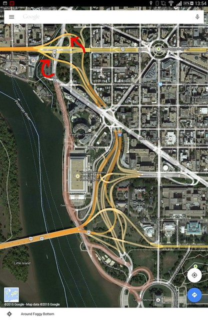
The KenCen, along with the Watergate complex and what’s now the Saudi embassy, stands in a tiny island isolated from both the city and the river by two parallel highways. Neil’s post focuses on a long history of proposals to bridge the chasm of I-66, built alongside this island as part of the grand urban renewal scheme that obliterated Foggy Bottom’s industrial heritage.

Yet the 1920s-era Rock Creek Parkway that runs on the riverfront through this stretch is perhaps a greater urban offense. It’s a limited-access highway that squeezes strolling pedestrians and cyclists into a narrow riverfront strip. It intervenes between the bike path and the river at one point, creating a particularly confusing, and dangerous, joint in the otherwise admirably complete trail network along the region’s waterways, and pretty much completely interrupting any pedestrian flow between the Mall and the waterfront. (Speaking of harrowing junctions, its at-grade intersection with I-66 creates a terrifying two-stage left turn at the end of I-66’s Independence Avenue ramp.)

And it could be eliminated with just two ramps — the ones shown in red in the map, linking the existing and underused ramps that link I-66 Extension to the Whitehurst Freeway, to Rock Creek Parkway. Adding these two ramps would enable cars that currently use Rock Creek Parkway to use the woefully empty I-66 that runs just two blocks east — and thus permit depaving Rock Creek Parkway (in pink), south of Virginia Avenue and north of the Lincoln Memorial.*

(A 1998 FHWA study also proposed the same ramp at the northeast quadrant of the interchange, but instead of a loop suggested a signal and a left exit. It also proposed to leave RCP, and grade-separated the Ohio/RCP intersection.)

Creating a linear park along the river between the Thompson Boat Center and the Lincoln Memorial would more clearly link three great linear open spaces — the Mall, Rock Creek Park, and Georgetown Waterfront Park and the upstream parks. (A clearer, perhaps grade-separated walkway behind the Lincoln Memorial would still be needed.) It would finally connect the KenCen and Watergate to the water, and break apart the asphalt chains that encircle the old Watergate Steps. It would also attach this little urban island to the city (well, Georgetown).

It would accomplish these aims at a cost far lower than decking over I-66, a proposal that has failed several times for want of funding. The surrounding renewal-era fabric would require retrofitting if such a deck were built, since most of it was built with high walls that ignore I-66.

Yes, direct access between Memorial Bridge and Rock Creek Parkway would be eliminated. Drivers would instead have access to the Roosevelt Bridge, which is currently denied, and could use Virginia and 23rd to reach Lincoln Circle and thus Memorial Bridge.

A similar concept was floated on POP in 2012 and roundly criticized in the comments, although it seems most of the commenters misunderstood which segment of RCP was being referred to.

* On second glance, the north Lincoln Memorial loop may be needed to allow Independence Avenue traffic to flow onto Memorial Bridge.

Downzoning R4: Zoning Commission testimony

Price per square foot premium

My name is Payton Chung, I live in yes, an apartment in Ward 6, and I am testifying with regard to Case 14-11.

This rezoning amounts to a severe reduction in the potential number of housing units within the District. This action seems incongruous with the Office of Planning’s recent arguments that the District is adding a thousand residents each month, which will result in exhausting its “zoned capacity” for new development within 25 years — and perhaps sooner, if ambitious plans like the Sustainable DC plan bear fruit.

OP has suggested that existing single-family neighborhoods should accommodate some of that growth, through accessory dwelling units and corner stores. Yet now OP has reversed course, shutting the window on secondary units in one-third of the central city, and in some regards (like with height) making R4 more restrictive than the lower-density R1, R2, and R3.

The supposed principal rationale that OP offers, that further restricting an already severely constrained supply of housing will somehow make housing more affordable to a select class of households, is spurious and discriminatory towards smaller households like mine. As former OP director Harriet Tregoning once said, “Part of the challenge is to right-size our housing stock so we can have the type of housing that matches the needs of our residents.”

Tregoning pointed out then that larger housing units are already amply supplied within the District. Today, there are 2.4 large housing units in DC for every one household that needs one. More specifically, 33.5% of our housing units have three or more bedrooms, but 13.9% of our households have four or more residents.

This imbalance results in the market awarding a substantial discount to large units. On a per square foot basis, three-bedroom units sell for 15% less than the citywide average, while zero and one bedroom units pay a 15% premium. And yet OP wishes to exacerbate this crisis by further constraining the supply of small housing units, with no guarantee that larger units will be at all affordable.

I happen to enjoy living in a high-rise apartment building, but it is neither feasible nor desirable to shoehorn all residential growth solely into the rapidly diminishing areas available for high-rises — which are, of course, subject to the Height Act. High-rises have intrinsically high costs due to their fireproof construction, elevators, and interior corridors.

It’s no accident that most of North America’s great urban neighborhoods, from Boston to Brooklyn to Chicago to San Francisco, are comprised of small, low-rise buildings with 2-4 units apiece. Such buildings are affordable to build and maintain, yet create just enough density to keep eyes on the street and shops within walking distance. In fact, Milwaukee reveres two-unit pop-ups as the city’s characteristic housing type — former mayor John Norquist described its so-called “Polish flats”  as a housing type “specifically designed both to accommodate and to accelerate the economic improvement of the family.”

Almost 40% of Boston households live in 2-4 unit buildings, and so do nearly one-fourth of households in New York City and San Francisco. Yet here in DC, scarcely one in nine of our households do.

This text amendment certainly has a number of supporters, but in the end we must also consider its inadvertent result: to deny thousands of people the option to live in neighborhoods like Columbia Heights, Mount Pleasant, Park View, Trinidad, and Capitol Hill; to further diminish the prospect of more walkable retail within these neighborhoods; to sharply limit investment in some of the region’s most centrally located areas; to make Washington even less affordable to the young strivers who are, more than ever, its lifeblood.

Thank you for your time.

Shorts: Critical Masses

Critical Mass I Ching

A few short topics for January, all around the theme of achieving critical mass in three very different markets for metropolitan services.

1. Nathan Donato-Weinstein, reporting for the Silicon Valley Business Journal about Google’s October purchase of buildings along San Francisco Bay:

Google — which like many expanding tech companies is focused on reducing its car and shuttle trips as traffic worsens during the current boom — may be eyeing transit options beyond freeways. Pacific Shores is a half mile from the Port of Redwood City, where a Google pilot project earlier this year tested running ferries from San Francisco and Alameda to the port. The Water Emergency Transportation Authority, which administers the San Francisco Bay Ferry routes, has studied regular public ferry service to Redwood City, with a potential public terminal practically next door to Pacific Shores.
“I know they really liked the ferry and the concept. Their challenge was getting people off a boat and putting them on a bus to Mountain View, and that was taking 25 minutes,” said Kevin Connolly, director of planning and development for WETA. “This might be one way to address it.” […]
A Redwood City terminal would cost about $15 million. But the county doesn’t have ongoing operational funding, Connolly said.
A major built-in user such as Google could help make service pencil out, he said.

I’ve written critically about the peculiar geometries (and thus poor economics) of water taxi transit before. Having high-density development built on landfill immediately adjacent to a deep-water port certainly solves some of those problems — but a ferry does need at least two ports. However, most other Bay Area jurisdictions have incredibly restrictive development policies along their waterfronts, and many of the Bay Area’s most desirable residential areas are well inland (and atop hills, in fact).

Perhaps last-mile bus service would supplement a 101-bypassing ferry on one or both ends. That adds in the time and hassle of a transfer; when combined with a lower peak speed (around 40 MPH) and increased susceptibility to inclement weather, it’s tough to see how it would be a faster, more reliable, or more fuel-efficient option. (2008 figures submitted to FTA, as reported by Wayne Cottrell in Energies, indicate that ferry operators in the USA have a median fuel economy of about 10 seat-miles per gallon of fuel.)

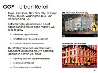
2. General Growth Properties plans a $2 billion investment in street retail, ultimately aiming to have 15% of its portfolio invested on high streets in the principal gateway cities of NYC, Chicago, Miami, Boston, DC, SF, and LA. Even in these high-rent areas, GGP sees “assets with significant unrealized growth potential,” with below-market rents and under-used vertical space.

General Growth Properties investor presentation slide

Many office REITs have focused on CBD office, but these properties have historically been neglected by large retail REITs. Adjacencies matter much more with retail than with office, which creates a “commons” problem that undermines streets with fragmented ownership.

GGP has hinted at two approaches to circumvent this. Like Acadia Realty Trust (an exceptional retail REIT that has redefined itself as a high-street owner), it might hope to aggregate enough properties to create its own mall-like ecosystem, and thus internalize the external benefits of its investment. GGP’s first big investment, an equity stake in the Miami Design District, certainly has that advantage. However, the DD is a singular example unlikely to be replicated elsewhere, so it appears that GGP will instead have to rely upon its high-rent neighbors to similarly aggressively upgrade their properties.

This could be a long waiting game, though, since a lot of urban property isn’t owned by others who need the same quick upside that a REIT does. Micah Maidenberg quotes a skeptic in Crain’s:

“The street-retail business, just like luxury hotels and other sorts of high-end projects, tend not to be a quarter-to-quarter-growth kind of business. It’s more of a long-term hold,” says Jeffrey Donnelly, a managing director at Wells Fargo Securities in Boston.

3. Two few weeks ago, I was visiting my parents in North Carolina and feeling under the weather. While looking up my out-of-area health care options, I came across an instructive article in Milbank Quarterly (by Daniel Gitterman, Bryan Weiner, Marisa Elena Domino, Aaron McKethan, and Alain Enthoven) about why Kaiser Permanente’s integrated group medical practice failed in the Triangle — where I’d previously been a satisfied customer.

My main takeaway from the case study was that, while “prepaid group practices” like Kaiser or GHC in Seattle (not to mention vertically integrated government systems like the VA) do offer tremendous cost efficiencies, they also rely on economies of scale that are difficult to set up from scratch.

The article estimates that KP’s break-even point is around 100,000 members in a metro area. That figure would have been a huge ask, given that the Triangle’s population was well below a million at that time, and spread out across a broad area. KP needs that kind of scale to build bargaining power, both:
– on the cost side, when bringing services in-house (the essential feature of their cost-containment model) or bargaining with hospitals and specialists; and
– on the revenue side, when selling their product to employers and employees who have to be sold on a choice that (a) most would find less convenient and (b) involves disrupting the “stay with my doctor” inertia many customers have.

It’s not a coincidence that prepaid group practices are best established in markets where either government employees or unionized employees bulk-purchase healthcare services. But HMOs are beginning to re-emerge now that the Triangle is bigger and denser, the ACA exchange has made the health insurance market less fragmented, and more doctors have organized into group practices linked to specialists via electronic health records. One new option in this year’s ACA marketplace for North Carolina (and especially valued, since last year only NC Blue Cross participated in the marketplace) is Coventry’s CareLink HMO, which uses Duke Medicine’s primary care network as the in-house practice.

New steel & wood innovations that make mid-rise construction easier, faster, cheaper

Earlier this year, I wrote about some new materials and techniques that could make structural engineering for mid-rise buildings easier, faster, and cheaper. If widely implemented, these could make human-scaled mid-rises more affordable, more widespread, and frankly better looking.

ConXTech

Steel makes elements like this penthouse easier to build. (Alas, the exterior’s been toned down from this glassy early rendering.)

1. While I was in California, I saw two examples of steel-framed mid-rise buildings constructed using ConXTech, an Erector Set-like approach to steel frames that promises to save time and money through computer-aided prefabrication. Eddie Kim writes in the LA Downtown News that the Eighth & Grand grocery + apartment building, “There’s no army of welders diligently fusing each joint and beam. Instead, steel girders are being lowered and snapped into place.”

Dan Garibaldi from developer Carmel Partners told Kim that the technique cut costs some, but really saved time and added design flexibility, particularly crucial in a mixed-use project: “We contracted for the steel at a beneficial time so the cost differential is not nearly what it would be today… The main benefit is how quickly we can complete the framing. In addition, ConXtech allowed us [to build] an additional residential floor and create long spans that are not easily achievable in wood frame.”

ConXTech co-founder Robert Simmons expressly invented the system to compete with Type III-over-I construction. He told Kim, “we were looking at ways to create a competitive method of structural framing versus wood and I couldn’t do it with concrete, so I started looking at steel.” His firm worked on the concrete retail podium at Santana Row in San Jose, which suffered a massive construction fire — not unlike recent fires that destroyed under-construction, pre-fireproofed Type III buildings in Mission Bay and on Bunker Hill.

Santana Row

Not Type III over I.

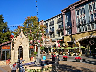
Santana Row’s upper-story apartments (and hotel) were rebuilt using ConXTech steel, and there are palpable differences between it and, say, Rockville Town Center (another Federal Realty development, built as conventional III-over-I), notably more generous window openings and a subtler transition above the podium. At Santana, the base of the building often extends above the second floor, allowing not just for retail mezzanines but also adding vertical articulation.

2. Cross-laminated timber is a particularly exciting new technology for D.C. buildings: under current building codes, it can reach up to 90′ high — the height limit outside of downtown — and uses wood, which is locally available, easy to work with (i.e., fast and inexpensive), and has a comparatively small carbon footprint. Plus, it can look like the old timber lofts of yesteryear, a building type I’ve long been fascinated with.

Architect Michael Green’s Wood Innovation and Design Centre in Prince George, B.C. was recently completed; it reaches 90′ with its eight stories — or, technically, five stories and a penthouse over a one-story podium with a mezzanine, a bit of creative accounting perhaps done to satisfy code requirements. But whatever, Prince George might as well be on the moon, since it’s 500km from even Edmonton or Vancouver.

A heavy timber loft for the 21st century, built with rapidly renewable materials.

What’s more notable is this seven-story speculative office building that fits right into downtown Minneapolis’ loft district, designed by Green and developed by office titan Hines. Sam Black writes in the Business Journal, “Unlike Warehouse District buildings such Butler Square and Ford Center that were built out of huge logs, modern timber buildings use wood engineered from several layers of younger trees.

Today’s office tenants disdain boring concrete high-rises, and even the new-construction concrete “lofts” that began popping up in the 2000s are a weak alternative. CLT offers architects a chance to build an authentic timber loft building, from scratch, and without harming old-growth trees. Bob Pfefferle from Hines told Kristen Leigh Painter of the Star-Tribune, “it provides an authentic building that is respectful of the neighborhood. This will have the ambience of the old warehouses with timber beams that everyone wants, but solves all the problems of energy efficiency and light.”

Coincidentally, this month’s Arch Record has a sponsored feature on “tall wood” buildings. The IBC, it points out, limits commercial-occupancy wood buildings to six stories (vs. five for residential), hence the seven stories that Hines is proposing.

I can imagine that similar new-build loft offices could be popular in similar downtown-adjacent submarkets, and transformative for Sunbelt cities where sparse “warehouse districts” have little competing product. I’m thinking Austin, Denver, Raleigh, San Diego, Seattle, or maybe infilling Bay Area subcenters like West Berkeley and Redwood City

Bike overnights from D.C. through Maryland

Harpers Ferry in October

My recent five-day bike tour through the mountains whetted my appetite for quicker escapes into the same countryside. Luckily, the DC region sits astride the fall line, which puts a variety of topographies within reach. This makes it possible to do a bike overnight, or more ambitiously, a sub-24-hour outing (S24O).

On such a short trip, it’s important to ride enough miles to make the trip an accomplishment, but not so many as to be exhausted or to preclude any off-bike adventures. One key to doing so is to strictly limit the mileage spent biking down dangerous streets in traffic-choked suburbs, and to take advantage of trails — particularly easy-grade rail or riverfront trails.

One weekday-only trip that combines these, starting in the District, is a bike trip from Poolesville, Md. to Harpers Ferry, W. Va., returning via the C&O Canal towpath along the Potomac. This takes advantage of Montgomery County’s urban growth boundary, the area’s extensive rush-hour bus system, and the centuries-old Potomac path.

One recent day, I awoke at 5 AM to board a Red Line train at 6 AM, leaving the system at Shady Grove just as the morning bike ban started. From there, I waited a few minutes for RideOn route 76, which on weekday peak hours travels from Shady Grove through Kentlands, then deep into the Ag Reserve, and eventually ends in the rural town of Poolesville. Like all RideOn buses, the buses sport dual bike racks. Interestingly, the largest business in downtown Poolesville is a tractor supply store — the last place I expected to be able to take a city bus to.

The historic center of Poolesville, Maryland, just past the terminus of RideOn route 76.

Poolesville is famous among area cyclists as a jumping-off point for rides on country roads, but I wasn’t aware of any car-free routes to get there until I scrutinized WMATA’s regional bus maps.

From Poolesville, it was a quick 5 1/2 mile, downhill ride down Whites Ferry and Wasche Road to the Dickerson Conservation Park, and then onto the C&O. Harpers Ferry is another 22 miles upriver, not far past the railroad-centric town of Brunswick, Md. Equally charming Shepherdstown, W.Va. is another 13 miles upriver.

The main street of Brunswick, Maryland.

Lodging and camping options along the way are plentiful. Shepherdstown and Harpers Ferry offer numerous B&Bs and hostels, while the C&O has walk-in campgrounds every few miles along the trail plus six historic cabins available for nightly rentals.

The return bike trip is all downhill, and can be accomplished in one day: It’s 61 miles from Harpers Ferry to Georgetown, or 73 miles back from Shepherdstown. 13 miles can be shaved by hopping across the river at White’s Ferry and picking up the W&OD trail in Leesburg, which also has a charming downtown, and ending at the Silver Line. (Even with just Phase 1, Silver extends further than any of Metro’s rail lines.)

Another, 7-day-a-week transit option that I’ve used is Metrobus B30 — yes, the BWI bus. It, too, has bike racks just like every other Metrobus, but unlike other Metrobuses it travels beyond the Patuxent River and into metro Baltimore. (This option takes much longer than MARC, which may soon add a bike car to its Penn Line weekend trains.)

From the BWI light rail station, a cyclist can:

  • Board a Baltimore light rail train into the city, with its fantastic neighborhoods and Olmsted trails — or to Hunt Valley, about half a mile short of the Northern Central Rail Trail north to York;
  • Connect to several other buses, notably MTA’s buses to Annapolis or RTA’s buses through Howard and Anne Arundel counties;
  • Ride up alongside the tracks to the BWI Trail and follow the signs to the B&A Rail-Trail to Annapolis and the Chesapeake shore;
  • Walk through the BWI Amtrak station, then ride north on Ridge Road and through old downtown Elkridge (not much there) to the Patapsco Valley state park’s trails and thence to Ellicott City.

(That said, biking all the way to Baltimore or Annapolis is certainly feasible. I’ve used Brock Bridge Road for the former, and Governors Bridge Road for the latter, and enjoyed a relatively low-stress trip. Next up: Metrobus to Olney, then riding via Columbia and Catonsville to Baltimore.)

Someday, urban cyclists in DC will be able to easily slice past the sprawl aboard commuter trains. It’s possible today to bring bikes aboard VRE midday trains, which makes it possible to leave early on Friday and ride back from Manassas or Fredericksburg. Another option to consider is VRE halfway, then a ride through the farms to Charlottesville (from F’burg or Manassas).

The region’s weekday commuter buses might also prove useful, although they’re certainly not geared to weekending cyclists. Loudoun Transit runs to Purcellville, aka the western end of the W&OD Trail, and appears to allow bikes for pre-registered users. Maryland’s commuter buses cover a vast territory from Hagerstown to the Eastern Shore, but have no specific bike policy.

Majority rule, minority rights — or Moses and NIMBYs

Terror alert

I snarkily wrote up a little headline last Monday: “Belmont Bypass’ Immediate Neighbors Slam Outreach, Will Vote On Keeping Bottleneck.” Then Daniel Kay Hertz wrote a somewhat fuller reponse, pointing out that a few people would vote on a project that impacts rail service for hundreds of thousands.

(Not surprisingly, the referendum failed, with 583 votes against. In June 2014, the three rail lines that would benefit from the bypass carried 6,353,313 passengers.)

Many broadly beneficial, but locally detrimental, projects are subject to being torpedoed by hyper-local concerns. As with any Locally Undesirable Land Use (LULU), the benefits are broadly distributed but the costs are highly focused. Many will gain a bit, but the benefits are in the distant future and somewhat speculative, so the issue has soft salience to the majority. On the other hand, a few will lose a lot, so those loss-averse few have a strong incentive to fight tooth and nail against threats to their homes. It’s just human nature.

Later comments directed at both Hertz and I raised the specter of Robert Moses bulldozing East Tremont for the Cross-Bronx Expressway. Yes, there are some surface similarities: properties expropriated for a transportation improvement. Yet these projects differ incredibly, not just in what is being done, but more importantly in how they are done.

A new highway arguably fails a cost-benefit analysis once social costs are calculated: It exacts leviathan costs, from destroying communities to contributing mightily to destabilizing the planet’s climate. (This probably even applied in Moses’ era, before thousands of miles of highways were built, subjecting further investments to the law of diminishing returns.) A new transit connection has a much better balance sheet. The Belmont Bypass has particularly high leverage, since it finally unleashes the bottlenecked potential of the miles of four-track structure beyond it.

More important is how the project is executed. In a democracy, the majority rules with respect for the basic rights of the minority. Moses infamously low-balled property owners when seizing land, and paid tenants (and rent-controlled tenants in an era of high housing inflation arguably hold a claim resembling property) almost nothing; such expropriation is clearly contrary to the Fifth Amendment or to the UDHR‘s Article 17.

Several property owners stand to lose their property to the Belmont Bypass. In such a high-profile situation, which public opinion broadly in their favor and multimillion-dollar properties on the line, I imagine that this group will receive just compensation — quite unlike the residents of East Tremont, who were largely ignored by the press, whose cries for help went almost entirely unheard by their legislators, and who lacked funds to file lawsuits.

Yes, a slightly larger population will be inconvenienced by construction for a few years, and this crowd appears to have provided most of those damning 583 votes. While pollution, even non-toxic pollution such as carbon, can justifiably be construed as violating others’ right to life, the noise and dust from construction can be mitigated to a significant extent.

In short, the substantial benefit that the majority will derive can justly be seen as outweighing the relatively minor rights claims in this instance, and the comparison to Robert Moses is spurious.

Of course, it’s rare for citywide transit agencies to make decisions at the hyperlocal level. Yet it’s absolutely typical for decisions to be made about permitting additional housing at almost a parcel level; in that case, the marginal benefit to other regional residents is so marginal as to be doubted entirely. Yet affordable rentals, in particular, are a LULU that local NIMBYs have successfully engineered the regulatory regime to discriminate against. Ryan Avent writes in the Economist: “The benefits and costs of population growth occur in a way that practically guarantees highly restrictive building rules.” Michael Lewyn takes the view that “cities cannot be trusted to weigh the citywide interest in new housing against neighborhood concerns… the chances of abuse are simply so high that a higher authority must step in.”

New economic geography: fewer centers, more edges

from a plane
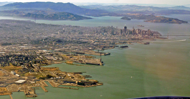
There’s obviously no room to build anything, anywhere.

October’s Economist Survey on the global economy by Ryan Avent included a shout-out to his Piketty-informed thoughts on housing prices. In short, the productivity gains from current technology have increased inequality between people and places. The returns on specialized skills are worth more in an era of cheap communication and transportation, great cities aggregate many people with such specialized skills –and furthermore, agglomeration effects appear to be growing even as communications costs decline. Even virtual reality won’t be able to replicate the everyday, subtle reinforcement of ambition that great cities provide; as Paul Graham writes:

The physical world is very high bandwidth, and some of the ways cities send you messages are quite subtle… A city speaks to you mostly by accident—in things you see through windows, in conversations you overhear. It’s not something you have to seek out, but something you can’t turn off.

Ideas have become so complex that those with specialized skills need to gather around others with complementary skills just to understand topics, much less to achieve the discovery or innovation stage. And, well, interesting people like one another; not for nothing has “assortative mating” taken off, spawning study of managing “the two-body problem” in fields like academia and medicine. (Hint: bigger cities, with bigger labor markets, are more likely to solve the problem. This has become a boon to universities recruiting in large metro areas, while those in small college towns struggle. The eight metro areas with 3+ R1 universities [Boston, New York, Philadelphia, Washington, Raleigh-Durham, Atlanta, Chicago, and Los Angeles] have a considerable advantage in this regard.)

In short, there are fewer centers and more edges. Scarcity being what it is, the centers (and only the centers) are winning more capital, and the edges are losing.

The result has been a highly uneven reallocation of wealth, whereby some places are winning in the form of skyrocketing property prices. These high prices create a substantial drag on the economy: increasingly high rents in the most productive locations steal from the most productive. This steers:

  1. Capital towards landlords, enlarging a rentier class (as Piketty notes) and starving more productive sectors.* This creates a vicious circle, as the NIMBY cartel further tightens its regulatory capture over the land use regime, and extracts ever-higher rents.
  2. Labor towards less costly, and less productive, places, creating economic losses. One recent study quantified that economic loss to the United States in 2009 at 13% of GDP — equivalent to sawing off the entire state of California.

—–

This might be worth unpacking further at a later date: Just reforming land-use regulations, or even entirely repealing the “shadow tax” of zoning, still won’t do enough to produce sufficient affordable housing. Even if zoning is reformed to “make more land,” that land’s still subject to construction’s “hard costs,” which are just too high nowadays.

Construction costs have risen faster than inflation, and far faster than stagnant workforce incomes. Slides 5-6 of this presentation [PDF] by Thomas Hoffman from Enterprise points out that even with free land, even the cheapest construction now costs 50% more than the affordable rent for a low-income family.

Sure, embedded within construction costs are other perhaps-useless regulations, but housing affordability in gateway cities is a problem with many root causes, and with many solutions as well.

—–

* Rent or mortgage principal paid, aka “housing service expenditure,” does not have a multiplier effect on GDP because it’s not factored into GDP. However, it’s worth noting that in 2000, HSE amounted to nearly $1 trillion, which supported only some of the 1.1 million jobs in real estate (NAICS 531). Reducing rental prices would take investment income from landlords and give them back to consumers, who would probably spend in other sectors that generate more jobs per dollar.

Trails don’t make a suburb walkable, urban fabric does

Paths in Greenbelt

Trail underpass in Greenbelt, Md.

A century ago, cars first started appearing on city streets and subsequently began running over everyone else. The 1920s epidemic of traffic fatalities, particularly among children, led to a fad in town planning to rigorously separate paths for cars and people, and to turn over the roads entirely to cars.

This philosophy was implemented in several New Towns — most notably in Radburn, New Jersey, but more extensively in three suburban Washington communities (Greenbelt, Columbia, and Reston). For the most part, though, existing cities proved too expensive to retrofit, and most other American suburbs just built the car-only roads without their pedestrian counterparts.

Garden side

Greenbelt Museum

In both Radburn and Greenbelt, houses were even “turned” to face the walkways, with back doors facing alley-like auto access roads. Yet as these places have matured, most households have rotated their houses and enclosed their public front yards into private backyards; communities have added sidewalks to the streets. (Above, the museum/house at right has been restored to its original appearance, but the house at left is typical.)

Reston: Lake Anne Village

Trail crossing street in Lake Anne Village, Reston, Va.

Examples built from the 1960s-1980s, like Reston, typically threaded trails past backyards. LIFE magazine wrote in 1965: “The need for automobiles in the village is virtually eliminated by a network of footpaths and bridges which connect residential areas with the shopping center.” (Indeed, my own 1960s neighborhood was replatted with a half-completed secondary grid, which I do use occasionally.)

Interestingly, two of my Streetsblog colleagues, Jeff Wood and Steven Vance, both lived in Kingwood, outside Houston, and both made extensive use of the trails as kids. In an email exchange, Steven writes:

Those trails, the Greenbelt, connected every subdivision with homes (there was an entrance 50 feet from my house), community pools, and passed behind every school. They also took me to the shopping areas. I “delivered” myself and my sister to school and the pool.

Jeff Wood made a distinction between walkability and runability on a recent episode of the Streetsblog podcast (sorry, can’t find the link!). While the trails in these communities are still prized as a recreational amenity, they are not a useful travel option for adults because they’re not really “irresistible”: distances are far (because densities are low), travel paths are circuitous, and there’s frankly not much to look at. While those attributes were suitable for Jeff’s track and field team, they don’t suffice for people walking to destinations — and who have the option of driving instead.

MWCOG travel survey

It later occurred to me that neighborhood-level household travel data is in fact available for one of these New Towns. In 2011, MWCOG did a geographically focused household travel survey aimed at understanding community scale differences in travel behavior. The chart above shows weekday trips for all purposes, arranged in distance from the regional core. The first five are within the Beltway, and the second five are outside the Beltway, but only Logan Circle is prewar fabric (within the L’Enfant City, even).

For a control, though, I’ll focus on White Flint. Both the Reston and White Flint survey areas have high household incomes, a high proportion of multifamily (49% in Reston, 61% in White Flint), upscale regional retail and substantial office employment at their core, and began development in the 1960s. White Flint has an established Metro line, higher density (6,000 residents/sq. mi.), and smaller households (1.4 average size). Reston’s Metro stop only opened recently, but it has had local and express bus service to other regional centers, larger households (2.2, still small by suburban standards), and generous open spaces that reduce overall density to 4,000/sq. mi. Most importantly, though, Reston has an extensive trail network, while White Flint has better street connectivity.

Sure, Reston has a substantial walk mode share of 14% — more than 50% higher than the regional average of 9%. Yet it’s not much higher than Woodbridge or Frederick, both of which have large expanses of haphazardly planned subdivisions surrounding a walkable “old town.” And it’s substantially below the 18% of trips that White Flint residents make on foot.

Steven points to Boulder and Davis as counter-examples: [T]hat kind of trail network that helps Boulder, CO, and Davis, CA, have high bicycling rates… [Boulder’s] bike map emphasizes their 10% bike-to-work mode share, while in Chicago we can’t seem to nudge past 1.6% (although for some neighborhoods it’s pushing 4.5%).

Yes, extensive trail networks are a great thing to have at a regional level, and certainly have something to do with the relative popularity of cycling in metro areas like the Twin Cities, Denver, and DC. Yet in explaining Boulder or Davis, I’d give less credit to infrastructure and more credit to favorable demographics, culture, and geography — they’re compact, connected, relatively high density, and mixed-use.

Every once in a while, I’ll encounter advocates who argue that trails are the only acceptable environment for pedestrians or cyclists, occasionally pointing to surveys showing that off-street trails are rated in most surveys as the gold standard of bike facilities, especially for those who don’t already regularly bike.

Sure, a trail network is great to have, and should be connected or created at every opportunity. However, we already have a fantastically extensive bike/ped circulation system that touches everyone’s front door — it’s just that our streets are filled with dangerous cars.

Yet the same surveys show that excellent on-street infrastructure is almost as good at enticing people onto two wheels. And since most new development will happen in places that are already built, it’s kind of a moot point, anyways.

Focusing on building up the fabric, and adding the best infrastructure available, is also the approach that Reston and White Flint are taking, and I expect that future household travel surveys will show that the approach will bear fruit for both areas.

[based on an email exchange]

Shorts: centripetal force, P3s, office park retrofit

Bubble map: growth in 25-34 population, 2010-2012

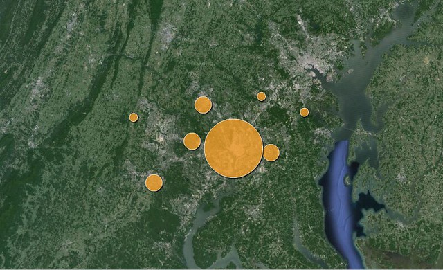
Growth in 25-34 population for DC-area counties, 2010-2012, with core jurisdictions aggregated for clarity. 42% of the growth is concentrated inside “the diamond,” which is home to 18% of the region’s population. A similar trend was noted in metropolitan NYC.

1a. Another recent report (by James Hughes and Joseph Seneca, reported by my colleague Stephen Miller) confirms that population growth has overwhelmingly shifted towards the core in the New York region since 2010. Third-ring suburban counties like Dutchess and Hunterdon are actually losing population, overall suburban population growth has slowed by 80% — and the core is on pace to recoup its entire 30-year postwar population loss (1950-1980) in just one decade (2010-2020).

Also echoed: a much larger proportion of young people (20-somethings) are heading downtown. “From 1970 to 1980, suburban counties captured 96 percent of the growth in this demographic. From 2010 to 2013, that figure dropped to 56 percent, with the urban core becoming increasingly competitive.” Since the report is from Rutgers, it defines “core jurisdictions” as including Hudson, Bergen, and Essex counties.

We’ve seen these trends reported in a national (PDF) and even DC context, but it’s worth noting since the NYC area is so huge and its economy has done well since 2010.

2. This week fall, Streetsblog USA will be publishing a three-part article I co-wrote with Angie Schmitt about what befell the Indiana Toll Road P3. Bad timing and bad traffic projections were just the tip of that iceberg.

3. Jonathan O’Connell from the Post reported last week that a new Fairfax County school was repurposed from an abandoned office building.

It’s a clever response to the changing Skyline/Bailey’s Crossroads neighborhood, where an aging housing stock and distance from transit have created a Toronto-esque high-density suburban immigrant enclave. Larger immigrant families have pushed up population density and school enrollment; retail is thriving, judging from the continued traffic jams and low vacancy rates. At the same time, office users have engaged in a “flight to quality,” towards newer and more efficient buildings closer to transit.

What’s more, the cost was very competitive. Fairfax spent $19 million in 2014 to buy and refit the building for 800 students (granted, a few amenities are still forthcoming) — which is right around the national median cost for a greenfield grade school in 2010.

Hong Kong’s revolution is in the streets, not the skyways

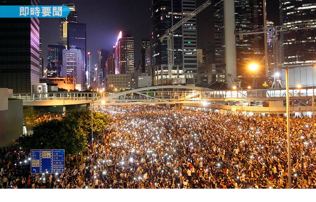
Even in “the city without ground,” #UmbrellaRevolution has taken not to the ersatz quasi-public spaces floating above Central, but instead to the ground — or at least to the traffic-sewer highways that fill what little is left of the ground:

(c)2014 NextMedia

It’s an interesting contrast with Occupy Wall Street, which happened to fill privately owned public space even though New York has comparatively more truly public spaces.

Trevor Boddy’s essay about North American “skyway” systems in Variations on a Theme Park seems prescient:

Heretofore streets functioned as periodic reminders and enforcers of the civic domain; the new patterns of city building remove even this remaining vestige of public life, replacing them with an analogue, a surrogate.

Precisely because downtown streets are the last preserve of something approaching a mixing of all sectors of society, their replacement by the sealed realm overhead and underground has enormous implications for all aspects of political life. Constitutional guarantees of free speech and of freedom of association and assembly mean much less if there is literally no peopled public space to serve as a forum in which to act out these rights…

[Protest] activities have been displaced over the past decade from the square and main street to the windswept emptiness of City Hall Mall or Federal Building Plaza. To encounter a ragtag mob of protestors in such places today renders them even more pathetic, their marginality enforced by a physical displacement into so unimportant, uninhabited, and unloved a civic location.

Only a full-scale revolt, involving hundreds of thousands, can be taken seriously under these conditions.

Not that a U.S. Supreme Court case matters much in this context, but Thurgood Marshall’s concurring opinion in the Pruneyard Shopping Center case is also worth remembering (emphasis added):

[S]hopping center owners had opened their centers to the public at large, effectively replacing the State with respect to such traditional First Amendment forums as streets, sidewalks, and parks…. Rights of free expression become illusory when a State has operated in such a way as to shut off effective channels of communication.

(Image of Occupy Central on Monday, 29 September 2014 from Apple Daily/NextMedia.)